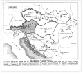
File:AustriaHungaryWWI.gif
Appearance

Size of this preview: 681 × 599 pixels. Other resolutions: 273 × 240 pixels | 545 × 480 pixels | 776 × 683 pixels.
Original file (776 × 683 pixels, file size: 98 KB, MIME type: image/gif)
File history
Click on a date/time to view the file as it appeared at that time.
| Date/Time | Thumbnail | Dimensions | User | Comment | |
|---|---|---|---|---|---|
| current | 05:39, 26 January 2022 |  | 776 × 683 (98 KB) | GPinkerton | Reverted to version as of 22:53, 20 January 2009 (UTC) COM:CROP, manipulation of historical images |
| 11:11, 27 December 2021 |  | 762 × 642 (97 KB) | Claude Zygiel | Sub-Carpathian Ruthenia never was Polish, this is not a "historical map" but an error of a newspaper: correcting it is not "manipulation". | |
| 04:31, 27 September 2021 |  | 776 × 683 (98 KB) | GPinkerton | Reverted to version as of 22:53, 20 January 2009 (UTC) COM:CROP, manipulation of historical images | |
| 09:27, 23 July 2020 |  | 762 × 642 (97 KB) | Claude Zygiel | Better (see [https://commons.wikimedia.org/wiki/File:Dissolution_of_Austria-Hungary.png]) | |
| 22:53, 20 January 2009 |  | 776 × 683 (98 KB) | Bizso | {{Information |Description={{en|New hand-drawn borders of Austria-Hungary in the Treaty of Trianon and Saint Germain.}} |Source=Transferred from [http://en.wikipedia.org en.wikipedia]; transfer was stated to be made by User:Bizso.<br/> (Original text |
File usage
The following 5 pages use this file:
Global file usage
The following other wikis use this file:
- Usage on azb.wikipedia.org
- Usage on bg.wikipedia.org
- Usage on ca.wikipedia.org
- Usage on cy.wikipedia.org
- Usage on el.wikipedia.org
- Usage on ga.wikipedia.org
- Usage on gl.wikipedia.org
- Usage on he.wikipedia.org
- Usage on hr.wikipedia.org
- Usage on hy.wikipedia.org
- Usage on id.wikipedia.org
- Usage on it.wikipedia.org
- Usage on ko.wikipedia.org
- Usage on lv.wikipedia.org
- Usage on pnb.wikipedia.org
- Usage on pt.wikipedia.org
- Usage on ru.wikipedia.org
- Usage on sh.wikipedia.org
- Usage on simple.wikipedia.org
- Usage on sk.wikipedia.org
- Usage on th.wikipedia.org
- Usage on ur.wikipedia.org
- Usage on vi.wikipedia.org
- Usage on zh.wikipedia.org


