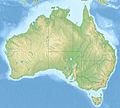
File:Australia relief map.jpg
Appearance

Size of this preview: 668 × 600 pixels. Other resolutions: 267 × 240 pixels | 534 × 480 pixels | 855 × 768 pixels | 1,140 × 1,024 pixels | 1,336 × 1,200 pixels.
Original file (1,336 × 1,200 pixels, file size: 366 KB, MIME type: image/jpeg)
File history
Click on a date/time to view the file as it appeared at that time.
| Date/Time | Thumbnail | Dimensions | User | Comment | |
|---|---|---|---|---|---|
| current | 07:38, 14 November 2010 |  | 1,336 × 1,200 (366 KB) | Виктор В | == {{int:filedesc}} == {{Information |Description={{en|Relief map of Australia}} Equirectangular projection, N/S stretching 110 %. Geographic limits of the map: * N: 9.0° S * S: 44.5° S * W: 111.5° E * E: 155.0° E |Source=* [[:File:A |
File usage
More than 100 pages use this file. The following list shows the first 100 pages that use this file only. A full list is available.
- 1989 Newcastle earthquake
- Abercrombie River
- Adelaide
- Adelaide Superbasin
- Amadeus Basin
- Anglo-Australian Telescope
- Anne Beadell Highway
- Ashburton River (Western Australia)
- Attack on Broome
- Australia Telescope Compact Array
- Australia Telescope National Facility
- Australian Astronomical Observatory
- Australian Masters
- Australian Open (golf)
- Australian PGA Championship
- Avon River (Mid-Coast Council)
- Bombing of Darwin
- Bowen Basin
- Bowman Park
- Brisbane
- Burning Mountain
- Canberra
- Canberra Deep Space Communication Complex
- Captains Mountain
- Carnarvon Tracking Station
- Darwin, Northern Territory
- Discovery Bay (Australia)
- Faulkes Telescope South
- Glenrock Lagoon
- Gondwana Rainforests
- Great Australian Bight
- Great Australian Bight Marine Park (Commonwealth waters)
- Great Barrier Reef Marine Park
- Greater Blue Mountains Area
- Groote Eylandt
- Gunbarrel Highway
- Heineken Classic
- Hobart
- Honeysuckle Creek Tracking Station
- Horizontal Falls
- Island Lagoon Tracking Station
- Jenolan Caves
- Johnnie Walker Classic
- K'gari
- Kangaroo Island
- Kata Tjuta
- King George Sound (Western Australia)
- Kronosaurus
- Lady Elliot Island
- Lake Barrine
- Lake Burley Griffin
- Lake Burragorang
- Lake Eacham (Queensland)
- Lake Macdonald
- Lake Mackay
- Melbourne Observatory
- Melville Island (Northern Territory)
- Molonglo Observatory Synthesis Telescope
- Mopra Telescope
- Morwell National Park
- Mount Chambers Gorge
- Mount Kosciuszko
- Mount Pleasant Radio Observatory
- Mount Stromlo Observatory
- Myall Lakes
- Narrabri Stellar Intensity Interferometer
- New Norcia Station
- Ningaloo Coast
- Old Hume Highway
- Operation Hurricane
- Outback Highway
- Parkes Observatory
- Paul Wild Observatory
- Perth
- Perth Observatory
- Pine Gap
- Reedy Creek Observatory
- Riversleigh World Heritage Area
- Royal Adelaide Golf Club
- Royal Melbourne Golf Club
- Shark Bay
- Siding Spring 2.3 m Telescope
- Siding Spring Observatory
- Siding Spring Survey
- SkyMapper
- Snowy River
- South Australian Open (golf)
- Spencer Gulf
- St Mary Peak
- Steamer Range
- Structure of the Australian Army
- Sydney
- Sydney Opera House
- Thredbo, New South Wales
- Toohey Mountain
- UK Schmidt Telescope
- Uluru
- Wet Tropics of Queensland
- Willandra Lakes Region
- Wilpena Pound
View more links to this file.
Global file usage
The following other wikis use this file:
- Usage on ab.wikipedia.org
- Usage on als.wikipedia.org
- Usage on am.wikipedia.org
- Usage on ar.wikipedia.org
- Usage on arz.wikipedia.org
- Usage on ast.wikipedia.org
- Usage on as.wikipedia.org
- Usage on azb.wikipedia.org
- Usage on az.wikipedia.org
- Böyük Suayırıcı sıra dağları
- Liverpul (dağ)
- Böyük Viktoriya səhrası
- Tasman dənizi
- Timor dənizi
- Eyr
- Uluru
- Hiller gölü
- Kakadu Milli Parkı
- Uluru–Kata-Tyuta Milli Parkı
- Purnululu Milli Parkı
- Şablon:Yer xəritəsi Avstraliya
- Freyzer (ada)
- Mərcan dənizi
- Kostyuşko (dağ)
- Bass boğazı
- Karpentariya körfəzi
- Spenser körfəzi
- Torres boğazı
- Dundas boğazı
- Tasman yarımadası
- Yanakie bərzəxi
- D'Antrkasto boğazı
- Undara Vulkanik Milli Parkı
- Kalbarri Milli Parkı
- Böyük Avstraliya körfəzi
- Torrens gölü
- Melvill (ada, Avstraliya)
- Bayron burnu
- York burnu (Avstraliya)
- Saut-Poynt
- Stip-Poynt burnu
- Böyük Qumlu səhra
View more global usage of this file.

