File:Attack on Schwaben Redoubt 1 July 1916 map.jpg
Appearance
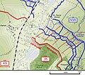
Attack_on_Schwaben_Redoubt_1_July_1916_map.jpg (596 × 500 pixels, file size: 71 KB, MIME type: image/jpeg)
File history
Click on a date/time to view the file as it appeared at that time.
| Date/Time | Thumbnail | Dimensions | User | Comment | |
|---|---|---|---|---|---|
| current | 23:43, 23 August 2009 |  | 596 × 500 (71 KB) | Rcbutcher | trimmed to cover smaller area |
| 23:27, 23 August 2009 |  | 690 × 618 (92 KB) | Rcbutcher | {{Information |Description=Map showing British attack in the vicinity of the Schwaben Redoubt on 1 July 1916. <br>This is a clip from the larger map of the Ancre sector File:Ancre sector 1 July 1916.png by [[:en:User:Gsl|Gsl] |
File usage
The following 3 pages use this file:
Global file usage
The following other wikis use this file:
- Usage on de.wikipedia.org
- Usage on nl.wikipedia.org
- Usage on ru.wikipedia.org

