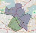
File:Ashfield parish map.svg
Appearance

Size of this PNG preview of this SVG file: 653 × 600 pixels. Other resolutions: 261 × 240 pixels | 522 × 480 pixels | 836 × 768 pixels | 1,115 × 1,024 pixels | 2,229 × 2,048 pixels | 899 × 826 pixels.
Original file (SVG file, nominally 899 × 826 pixels, file size: 2.38 MB)
File history
Click on a date/time to view the file as it appeared at that time.
| Date/Time | Thumbnail | Dimensions | User | Comment | |
|---|---|---|---|---|---|
| current | 13:17, 8 September 2010 |  | 899 × 826 (2.38 MB) | 99of9 | {{Information |Description={{en|1=A map of the Anglican Parish of Ashfield, Five Dock, and Haberfield, in Sydney, New South Wales, Australia. The blue tinted overlay is the original Parish of Ashfield, and the green tinted overlay is the original Parish |
File usage
The following page uses this file:

