
File:April 14, 2011 tornado outbreak satellite.png

Size of this preview: 677 × 599 pixels. Other resolutions: 271 × 240 pixels | 542 × 480 pixels | 939 × 831 pixels.
Original file (939 × 831 pixels, file size: 947 KB, MIME type: image/png)
| This is a file from the Wikimedia Commons. Information from its description page there is shown below. Commons is a freely licensed media file repository. You can help. |
Summary
| Description |
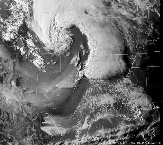
English: Visible Satellite Image of the storm system affecting eastern OK. Image valid 6:45 pm CDT 4/14/2011 |
| Date | |
| Source | http://www.srh.noaa.gov/news/display_cmsstory.php?wfo=tsa&storyid=66688&source=0 |
| Author | National Weather Service in Tulsa, Oklahoma |
| Permission (Reusing this file) |
Public Domain |
Licensing
This image is in the public domain because it contains materials that originally came from the U.S. National Oceanic and Atmospheric Administration, taken or made as part of an employee's official duties.
|
File history
Click on a date/time to view the file as it appeared at that time.
| Date/Time | Thumbnail | Dimensions | User | Comment | |
|---|---|---|---|---|---|
| current | 01:00, 18 April 2011 | | 939 × 831 (947 KB) | Supportstorm | Corrected Brightness |
| 16:44, 15 April 2011 |  | 939 × 831 (643 KB) | Cyclonebiskit | {{Information |Description ={{en|1=Visible Satellite Image of the storm system affecting eastern OK. Image valid 6:45 pm CDT 4/14/2011 }} |Source =http://www.srh.noaa.gov/news/display_cmsstory.php?wfo=tsa&storyid=66688&source=0 |Author |
File usage
The following page uses this file:
Global file usage
The following other wikis use this file:
- Usage on de.wikinews.org
- Usage on es.wikipedia.org