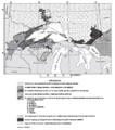
File:Animikie Group and Marquette Range and Huronian supergroups.PNG
Appearance
Animikie_Group_and_Marquette_Range_and_Huronian_supergroups.PNG (386 × 436 pixels, file size: 59 KB, MIME type: image/png)
File history
Click on a date/time to view the file as it appeared at that time.
| Date/Time | Thumbnail | Dimensions | User | Comment | |
|---|---|---|---|---|---|
| current | 04:39, 21 May 2010 |  | 386 × 436 (59 KB) | Bettymnz4 | {{Information |Description={{en|1=Map showing Animikie Group, Marquette Range and Huronian supergroups and iron ranges}} |Source=USGS url=http://pubs.usgs.gov/pp/pp1730/pdf/PP1730.pdf |Author=USGS |Date= |Permission= |other_versions= }} |
File usage
The following page uses this file:

