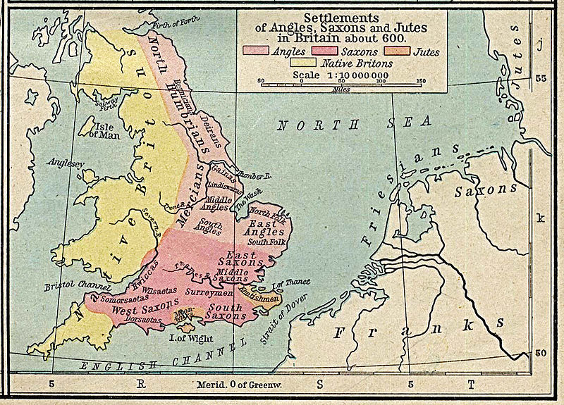
File:Angles, Saxons, Jutes in Britain year 600.jpg
Appearance

Size of this preview: 800 × 575 pixels. Other resolutions: 320 × 230 pixels | 640 × 460 pixels | 1,024 × 737 pixels | 1,126 × 810 pixels.
Original file (1,126 × 810 pixels, file size: 301 KB, MIME type: image/jpeg)
File history
Click on a date/time to view the file as it appeared at that time.
| Date/Time | Thumbnail | Dimensions | User | Comment | |
|---|---|---|---|---|---|
| current | 18:21, 17 April 2013 |  | 1,126 × 810 (301 KB) | Hohum | Levels |
| 17:26, 18 April 2006 |  | 1,126 × 810 (230 KB) | Alexquendi~commonswiki | es: Mapa de Gran Bretaña en el año 600, con la correspondiente distribución de los pueblos Anglos, Sajones y Jutos. Autorización del autor: Unless marked otherwise, the maps scanned by the University of Texas Libraries are in the public domain. The m |
File usage
The following page uses this file:
Global file usage
The following other wikis use this file:
- Usage on arz.wikipedia.org
- Usage on ast.wikipedia.org
- Usage on br.wikipedia.org
- Usage on ca.wikipedia.org
- Usage on de.wikipedia.org
- Usage on es.wikipedia.org
- Usage on he.wikipedia.org
- Usage on it.wikipedia.org
- Usage on nl.wikipedia.org
- Usage on ro.wikipedia.org
- Usage on sv.wikipedia.org
- Usage on uk.wikipedia.org
- Usage on vls.wikipedia.org
