File:Anatolia1300.png
Appearance
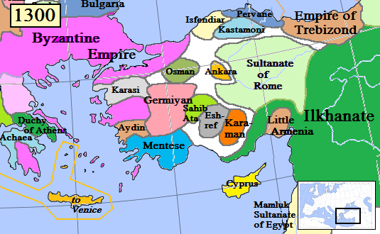
Anatolia1300.png (535 × 330 pixels, file size: 81 KB, MIME type: image/png)
File history
Click on a date/time to view the file as it appeared at that time.
| Date/Time | Thumbnail | Dimensions | User | Comment | |
|---|---|---|---|---|---|
| current | 16:46, 20 January 2017 |  | 535 × 330 (81 KB) | Cplakidas | fixing Dodecanese: Menteshe never controlled the offshore islands; they remained Byzantine until the Hospitallers or Genoese of Chios took them. |
| 22:26, 17 April 2009 |  | 535 × 330 (64 KB) | Gabagool | Byzantine color lighter. New Armenia -> Little Armenia | |
| 19:12, 2 April 2009 |  | 535 × 330 (64 KB) | Gabagool | added mamluks | |
| 16:36, 31 March 2009 |  | 535 × 330 (63 KB) | Gabagool | {{Information |Description={{en|1=Map of the Anatolia region in AD 1300. (Partially based on Euratlas map of Europe, 1300.)}} |Source=Own work by uploader |Author=Gabagool |Date=2009-03-31 |Permission= |other_versions= }} <!--{{ImageUp |
File usage
The following 15 pages use this file:
- Alexios Philanthropenos
- Armenian Kingdom of Cilicia
- Catalan Company
- Crusades after the fall of Acre, 1291–1399
- Emirate
- Germiyanids
- Güneri of Karaman
- John Tarchaneiotes
- Karamanids
- Karasid dynasty
- Menteshe
- Mesud II
- Sahib Ataids
- User:Falcaorib/Medieval Empires (1300-1500 AD)
- User:Falcaorib/Turkey and Ottoman Empire
Global file usage
The following other wikis use this file:
- Usage on als.wikipedia.org
- Usage on arz.wikipedia.org
- Usage on azb.wikipedia.org
- Usage on az.wikipedia.org
- Usage on ba.wikipedia.org
- Usage on bg.wikipedia.org
- Usage on bn.wikipedia.org
- Usage on ca.wikipedia.org
- Usage on cs.wikipedia.org
- Usage on de.wikipedia.org
- Usage on el.wikipedia.org
- Usage on es.wikipedia.org
- Usage on et.wikipedia.org
- Usage on fa.wikipedia.org
- Usage on fi.wikipedia.org
- Usage on fr.wikipedia.org
- Usage on gl.wikipedia.org
- Usage on he.wikipedia.org
View more global usage of this file.


