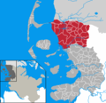
File:Amt Suedtondern in NF.png
Appearance
Amt_Suedtondern_in_NF.png (353 × 340 pixels, file size: 8 KB, MIME type: image/png)
File history
Click on a date/time to view the file as it appeared at that time.
| Date/Time | Thumbnail | Dimensions | User | Comment | |
|---|---|---|---|---|---|
| current | 18:08, 11 October 2019 |  | 353 × 340 (8 KB) | NordNordWest | upd |
| 16:31, 13 April 2007 |  | 353 × 340 (7 KB) | Ditschi | ||
| 16:30, 13 April 2007 |  | 353 × 340 (7 KB) | Ditschi | + Gemeindegrenzen | |
| 15:38, 9 March 2007 |  | 353 × 340 (12 KB) | Timt | == Beschreibung == * en: This map shows the area of the Amt (group of municipalities) de:Amt Südtondern in the Kreis (district) Nordfriesland, Schleswig-Holstein, Germany. * de: Diese Karte zeigt das Gebiet des Amts [[:de:Amt Südtondern|Südtonde |
File usage
The following page uses this file:
Global file usage
The following other wikis use this file:
- Usage on ca.wikipedia.org
- Usage on da.wikipedia.org
- Usage on de.wikipedia.org
- Usage on eo.wikipedia.org
- Usage on frr.wikipedia.org
- Naibel
- Risem-Lonham
- Doogebel
- Leek
- Amt Süüdtondern
- Åktoorp/mo
- Oowentoft/mo
- Bousbel/mo
- Braarep/mo
- Ämelsbel-Hoorbel/mo
- Åmt Söödtuner
- Vorlage:Gemiine foont Åmt Söödtuner
- Runees/mo
- Älhood/mo
- Äphüsem/mo
- Ding-Sönj/mo
- Språkebel/mo
- Ståårem/mo
- Weestre/mo
- Taningstää/mo
- Stääsönj/mo
- Naischöspel/mo
- Friedrich-Wilhelm-Lübke-Kuuch/mo
- Galmsbel/mo
- Leeksguurd/mo
- Braamstäälönj/mo
- Hulm/mo
- Humptoorp/mo
- Klasbel/mo
- Kuurlem/mo
- Klangsbel/mo
- Låålönj/mo
- Läigem/mo
- Amt Sörtoner
- Usage on fr.wikipedia.org
- Usage on it.wikipedia.org
- Usage on nl.wikipedia.org
- Usage on pl.wikipedia.org
- Usage on ru.wikipedia.org
- Usage on www.wikidata.org
- Usage on zh-min-nan.wikipedia.org


