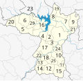
File:Amphoe Khon Kaen.svg
Appearance

Size of this PNG preview of this SVG file: 619 × 600 pixels. Other resolutions: 248 × 240 pixels | 496 × 480 pixels | 793 × 768 pixels | 1,057 × 1,024 pixels | 2,114 × 2,048 pixels | 1,115 × 1,080 pixels.
Original file (SVG file, nominally 1,115 × 1,080 pixels, file size: 118 KB)
File history
Click on a date/time to view the file as it appeared at that time.
| Date/Time | Thumbnail | Dimensions | User | Comment | |
|---|---|---|---|---|---|
| current | 17:04, 3 January 2019 |  | 1,115 × 1,080 (118 KB) | StackNats | Changed number |
| 13:06, 12 September 2009 |  | 1,115 × 1,080 (245 KB) | Hdamm | Changed text objects into paths | |
| 13:02, 12 September 2009 |  | 1,115 × 1,080 (215 KB) | Hdamm | removed black square (?) | |
| 12:43, 12 September 2009 |  | 1,116 × 1,076 (215 KB) | Hdamm | +background | |
| 12:38, 12 September 2009 |  | 1,116 × 1,076 (215 KB) | Hdamm | {{Information |Description={{en|1=Map of Khon Kaen province, Thailand, with the districts (Amphoe) numbered. #Mueang Khon Kaen (อำเภอเมืองขอนแก่น) #Ban Fang (อำเภอบ้านฝาง) #Phra Yuen (อำเภ |
File usage
The following page uses this file:
Global file usage
The following other wikis use this file:
- Usage on be.wikipedia.org
- Usage on ca.wikipedia.org
- Usage on de.wikipedia.org
- Usage on fi.wikipedia.org
- Usage on gl.wikipedia.org
- Usage on incubator.wikimedia.org
- Usage on th.wikipedia.org
- Usage on th.wiktionary.org
- Usage on tl.wikipedia.org
- Usage on tr.wikipedia.org
- Usage on www.wikidata.org
- Usage on zh.wikipedia.org
