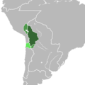
File:Alto Perú mapa.png
Appearance

Size of this preview: 600 × 600 pixels. Other resolutions: 240 × 240 pixels | 480 × 480 pixels | 1,000 × 1,000 pixels.
Original file (1,000 × 1,000 pixels, file size: 44 KB, MIME type: image/png)
File history
Click on a date/time to view the file as it appeared at that time.
| Date/Time | Thumbnail | Dimensions | User | Comment | |
|---|---|---|---|---|---|
| current | 13:05, 4 July 2023 |  | 1,000 × 1,000 (44 KB) | Oxfire35789 | Reverted to version as of 14:55, 21 April 2023 (UTC) No confundir Alto Perú —denominación territorial— con Estado del Alto Perú —proyecto de integración provincias para crear un nuevo Estado. |
| 14:58, 26 June 2023 |  | 2,000 × 2,000 (485 KB) | Ruditaly | Reverted to version as of 02:25, 13 April 2023 (UTC) El Alto Perú incluía la provincia de Santa Cruz de la Sierra, de acuerdo al Decreto del 9 de febrero de 1825 de convocatoria a la Asamblea General de Diputados de las Provincias del Alto Perú, y de acuerdo al Acta de la Independencia de las provincias del Alto Perú del 6 de agosto de 1825. | |
| 14:55, 21 April 2023 |  | 1,000 × 1,000 (44 KB) | Oxfire35789 | Reverted to version as of 20:22, 6 February 2023 (UTC) El Alto Perú es la región del norte del virreinato y de las Provincias Unidas del Río de la Plata, donde se tenía presente la cultura andina similar al sur peruano. | |
| 02:25, 13 April 2023 |  | 2,000 × 2,000 (485 KB) | Stars415 | Reverted to version as of 14:27, 26 November 2022 (UTC) | |
| 20:22, 6 February 2023 |  | 1,000 × 1,000 (44 KB) | Oxfire35789 | Se dijo, no era una entidad territorial, era una Región Geográfica que no estaba dirigida hacia Santa Cruz (que incluía Cordillera), ni sur de Moxos, tampoco hacia el extremo norte de La Paz. Tampoco se hizo una expedición, sino una comisión (desde el Alto Perú (en Potosí) hacia la provincia de Santa Cruz). Una vez más, Alto Perú: región alta del noroeste del Río de la Plata y con una cultura similar al del sur del Perú. | |
| 17:56, 6 February 2023 |  | 1,000 × 1,000 (30 KB) | Bodoque9903 | Un area regional no puede tener reclamaciones territoriales, no es una entidad territorial, es una región, y cuando los rioplatenses hacian las expedicones hacia Santa Cruz o Cochabamba llamaban expediciones "Alto Perú" | |
| 13:57, 5 February 2023 |  | 1,000 × 1,000 (44 KB) | Oxfire35789 | La región del Alto Perú era sólo la región alta de Bolivia, y también donde presentaban una cultura similar a la del sur del Perú. No Santa Cruz, ni el sur de Moxos, ni el extremo norte de La Paz. | |
| 23:17, 3 February 2023 |  | 1,000 × 1,000 (30 KB) | Bodoque9903 | Alto Perú era una región no una entidad territorial, no se puede decir que tenia reclamaciónes territoriales, es como habla de la región amazonica, además los rioplatenses llamaban alto peru incluso a la intendencia de Cochamba que incluina Santa Cruz, exceptuandose Moxos y Chiquitos | |
| 12:08, 14 January 2023 |  | 1,000 × 1,000 (44 KB) | Oxfire35789 | ||
| 18:30, 8 January 2023 |  | 1,000 × 1,000 (30 KB) | Bodoque9903 | Agrege todas las regiones que también eran denominadas como Alto Perú |
File usage
The following page uses this file:
Global file usage
The following other wikis use this file:
- Usage on ar.wikipedia.org
- Usage on ca.wikipedia.org
- Usage on de.wiktionary.org
- Usage on es.wikipedia.org
- Usage on eu.wikipedia.org
- Usage on fr.wikipedia.org
- Usage on fr.wiktionary.org
- Usage on it.wikipedia.org
- Usage on ja.wikipedia.org
- Usage on la.wikipedia.org
- Usage on ms.wikipedia.org
- Usage on www.wikidata.org


