
File:AlbaniaHas.png
No higher resolution available.
AlbaniaHas.png (106 × 225 pixels, file size: 17 KB, MIME type: image/png)
| This is a file from the Wikimedia Commons. Information from its description page there is shown below. Commons is a freely licensed media file repository. You can help. |
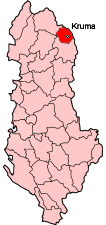
District of Albania

|
Permission is granted to copy, distribute and/or modify this document under the terms of the GNU Free Documentation License, Version 1.2 or any later version published by the Free Software Foundation; with no Invariant Sections, no Front-Cover Texts, and no Back-Cover Texts. A copy of the license is included in the section entitled GNU Free Documentation License. |
| This file is licensed under the Creative Commons Attribution-Share Alike 3.0 Unported license. | ||
| ||
| This licensing tag was added to this file as part of the GFDL licensing update. |
| Annotations | This image is annotated: View the annotations at Commons |
File history
Click on a date/time to view the file as it appeared at that time.
| Date/Time | Thumbnail | Dimensions | User | Comment | |
|---|---|---|---|---|---|
| current | 22:36, 7 January 2007 | | 106 × 225 (17 KB) | Albinfo | Updating maps to reflect acutal borders of Albanian districts |
| 18:14, 19 March 2005 |  | 100 × 225 (17 KB) | Qurqa~commonswiki |
File usage
The following page uses this file:
Global file usage
The following other wikis use this file:
- Usage on de.wikipedia.org
- Usage on fa.wikipedia.org
- Usage on fr.wikipedia.org
- Usage on hr.wikipedia.org
- Usage on ja.wikipedia.org
- Usage on ko.wikipedia.org
- Usage on lmo.wikipedia.org
- Usage on mk.wikipedia.org
- Usage on ms.wikipedia.org
- Usage on no.wikipedia.org
- Usage on pl.wikipedia.org
- Okręg Has
- Krumë
- Gmina Krume
- Gmina Golaj
- Gmina Gjinaj
- Gmina Fajzë
- Golaj
- Bardhaj
- Dobrunë
- Helshan
- Kostur (Albania)
- Letaj (Albania)
- Nikoliq
- Peraj (gmina Golaj)
- Perollaj
- Qarr
- Vlahën
- Zgjeç
- Gjinaj
- Pusi i Thatë
- Myç-Has
- Domaj
- Pogaj
- Kishaj
- Fajzë
- Vranisht
- Tregtan
- Liqen i Kuq
- Metaliaj
- Brenogë
- Szablon:Okręg Has
- Cahan (gmina Krume)
- Gajrep
- Krumë (wieś)
- Mujaj-Dajç
- Zahrisht
- Usage on pt.wikipedia.org
- Usage on ro.wikipedia.org
- Usage on sk.wikipedia.org
- Usage on sv.wikipedia.org
View more global usage of this file.