
File:Alba Patera - topography map.png

Size of this preview: 601 × 599 pixels. Other resolutions: 241 × 240 pixels | 623 × 621 pixels.
Original file (623 × 621 pixels, file size: 395 KB, MIME type: image/png)
| This is a file from the Wikimedia Commons. Information from its description page there is shown below. Commons is a freely licensed media file repository. You can help. |
| Description |
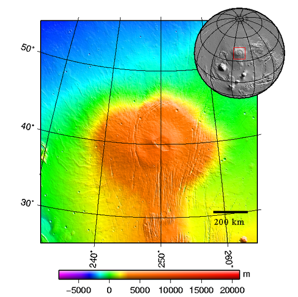
Čeština: Štítová sopka Alba Patera na Marsu - topografická mapa English: Topography map of shield vulcano Alba Patera on Mars |
||||||||
| Date | 2008-03-see below | ||||||||
| Source | plotted using GMT and gridded MOLA data archive meg0031t.grd | ||||||||
| Author | Chmee2 | ||||||||
| Permission (Reusing this file) |
I, the copyright holder of this work, hereby publish it under the following licenses:
This file is licensed under the Creative Commons Attribution-Share Alike 2.5 Generic, 2.0 Generic and 1.0 Generic license.
You may select the license of your choice. |

File history
Click on a date/time to view the file as it appeared at that time.
| Date/Time | Thumbnail | Dimensions | User | Comment | |
|---|---|---|---|---|---|
| current | 22:48, 10 March 2008 | | 623 × 621 (395 KB) | Chmee2 | {{Information |Description={{cs|Štítová sopka Alba Patera na Marsu - topografická mapa}} {{en|Topography map of shield vulcano Alba Patera on Mars}} |Source=plotted using GMT and gridded MOLA data archive meg0031t.grd |Date=2008-03-see below |Author=[ |
File usage
The following 2 pages use this file:
Global file usage
The following other wikis use this file:
- Usage on ca.wikipedia.org
- Usage on cs.wikipedia.org
- Usage on de.wikipedia.org
- Usage on es.wikipedia.org
- Usage on fa.wikipedia.org
- Usage on fi.wikipedia.org
- Usage on fr.wikipedia.org
- Usage on it.wikipedia.org
- Usage on ja.wikipedia.org
- Usage on ko.wikipedia.org
- Usage on lt.wikipedia.org
- Usage on nl.wikipedia.org
- Usage on nn.wikipedia.org
- Usage on no.wikipedia.org
- Usage on pl.wikipedia.org
- Usage on pt.wikipedia.org
- Usage on ru.wikipedia.org
- Usage on uk.wikipedia.org
- Usage on www.wikidata.org
- Usage on zh.wikipedia.org