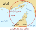
File:Al Qawasem Map.png
Appearance

Size of this preview: 696 × 600 pixels. Other resolutions: 279 × 240 pixels | 557 × 480 pixels | 891 × 768 pixels | 1,188 × 1,024 pixels | 1,476 × 1,272 pixels.
Original file (1,476 × 1,272 pixels, file size: 725 KB, MIME type: image/png)
File history
Click on a date/time to view the file as it appeared at that time.
| Date/Time | Thumbnail | Dimensions | User | Comment | |
|---|---|---|---|---|---|
| current | 21:53, 24 March 2008 |  | 1,476 × 1,272 (725 KB) | Producer | {{Information |Description= This is a map of the territory that the Qawasem Ruled Late 18th Century and early 19th century traced from the map 80px |Source=self-made |Date=22/3/2008 |Author= Nasib Bitar |
| 16:18, 23 March 2008 |  | 1,468 × 1,042 (659 KB) | Producer | {{Information |Description= This is a map of the territory that the Qawasem Ruled Late 18th Century and early 19th century traced from the map 80px |Source=self-made |Date=22/3/2008 |Author= Nasib Bitar | |
| 16:27, 22 March 2008 |  | 1,455 × 1,037 (606 KB) | Producer | {{Information |Description= This is a map of the territory that the Qawasem Ruled Late 18th Century and early 19th century traced from the map 80px |Source=self-made |Date=22/3/2008 |Author= Nasib Bitar |
File usage
The following page uses this file:

