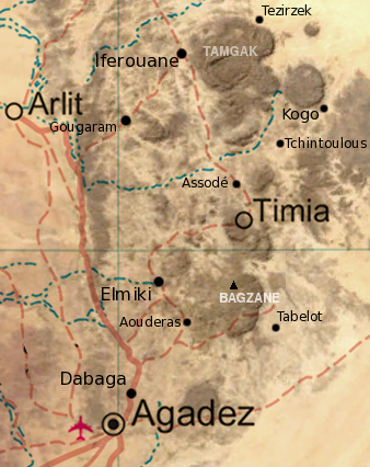
File:Air massif sat map south.png
Appearance
Air_massif_sat_map_south.png (338 × 426 pixels, file size: 235 KB, MIME type: image/png)
File history
Click on a date/time to view the file as it appeared at that time.
| Date/Time | Thumbnail | Dimensions | User | Comment | |
|---|---|---|---|---|---|
| current | 19:31, 17 December 2008 |  | 338 × 426 (235 KB) | T L Miles | {{Information |Description= Map of the southern half of the Air Massif, northern Niger. Created from an overlay of PD File:Un-niger.png and PD File:Niger_BMNG.png, plus map locations derived from fallingrain.com. |Source=*Image:Niger_BMNG.png |Date= |
File usage
The following 9 pages use this file:
Global file usage
The following other wikis use this file:
- Usage on ar.wikipedia.org
- Usage on bg.wikipedia.org
- Usage on ceb.wikipedia.org
- Usage on de.wikipedia.org
- Usage on el.wikipedia.org
- Usage on eo.wikipedia.org
- Usage on es.wikipedia.org
- Usage on fi.wikipedia.org
- Usage on fr.wikipedia.org
- Usage on ha.wikipedia.org
- Usage on he.wikipedia.org
- Usage on id.wikipedia.org
- Usage on it.wikipedia.org
- Usage on no.wikipedia.org
- Usage on ru.wikipedia.org
- Usage on sr.wikipedia.org
- Usage on uk.wikipedia.org
- Usage on www.wikidata.org
- Usage on xh.wikipedia.org

