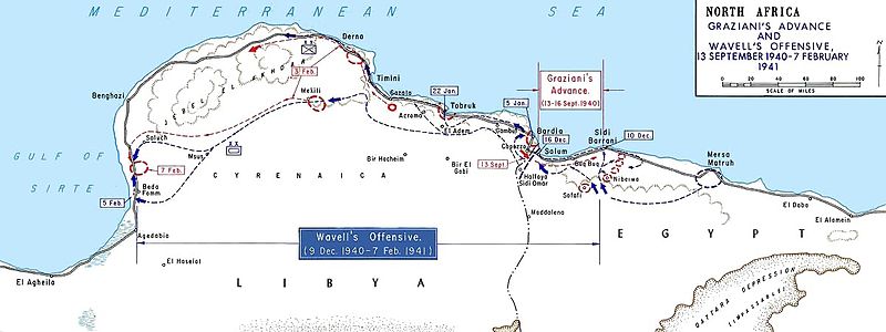
File:AfricaMap1.jpg
Appearance

Size of this preview: 800 × 300 pixels. Other resolutions: 320 × 120 pixels | 1,202 × 451 pixels.
Original file (1,202 × 451 pixels, file size: 101 KB, MIME type: image/jpeg)
File history
Click on a date/time to view the file as it appeared at that time.
| Date/Time | Thumbnail | Dimensions | User | Comment | |
|---|---|---|---|---|---|
| current | 13:52, 27 March 2011 | 1,202 × 451 (101 KB) | Hohum | cleanup | |
| 13:36, 6 May 2007 | 1,202 × 451 (128 KB) | Chanueting | {{Information |Description=Graziani's advance and Wavell's offensive -- en:September 13, en:1940 - en:February 7, en:1941 Source: US ARMY License: US Government document. Printed by the Government printing office. Assumed public doma |
File usage
The following 17 pages use this file:
- Attack on Nibeiwa
- Battle of Beda Fomm
- Battle of Sidi Barrani
- Beda Fomm
- British capture of Tobruk
- Combeforce
- German radio intelligence operations during World War II
- Maletti Group
- Military history of Australia during World War II
- Military history of Italy during World War II
- Richard O'Connor
- Southern Rhodesia in World War II
- Via della Vittoria
- Western Desert campaign
- User:Ian Rose/Draft3
- File talk:AfricaMap1.jpg
- Portal:Military history of Australia
Global file usage
The following other wikis use this file:
- Usage on ar.wikipedia.org
- Usage on azb.wikipedia.org
- Usage on bg.wikipedia.org
- Usage on ca.wikipedia.org
- Usage on da.wikipedia.org
- Usage on de.wikipedia.org
- Usage on en.wikibooks.org
- Usage on es.wikipedia.org
- Usage on fa.wikipedia.org
- Usage on fi.wikipedia.org
- Usage on fr.wikipedia.org
- Usage on gl.wikipedia.org
- Usage on ha.wikipedia.org
- Usage on hu.wikipedia.org
- Usage on hy.wikipedia.org
- Usage on it.wikipedia.org
- Usage on ja.wikipedia.org
- Usage on ko.wikipedia.org
- Usage on nl.wikipedia.org
View more global usage of this file.


