File:Administrative Districts of Germany 1981-2008.svg
Appearance

Size of this PNG preview of this SVG file: 439 × 599 pixels. Other resolutions: 176 × 240 pixels | 352 × 480 pixels | 563 × 768 pixels | 750 × 1,024 pixels | 1,500 × 2,048 pixels | 1,351 × 1,844 pixels.
Original file (SVG file, nominally 1,351 × 1,844 pixels, file size: 1.39 MB)
File history
Click on a date/time to view the file as it appeared at that time.
| Date/Time | Thumbnail | Dimensions | User | Comment | |
|---|---|---|---|---|---|
| current | 14:33, 1 October 2009 |  | 1,351 × 1,844 (1.39 MB) | Exec | Neuhaus again |
| 14:29, 1 October 2009 |  | 1,351 × 1,844 (1.39 MB) | Exec | adding fact of Neuhaus | |
| 13:59, 30 September 2009 |  | 1,351 × 1,844 (1.39 MB) | Exec | another translation error solved | |
| 13:56, 30 September 2009 |  | 1,351 × 1,844 (1.39 MB) | Exec | translation error solved | |
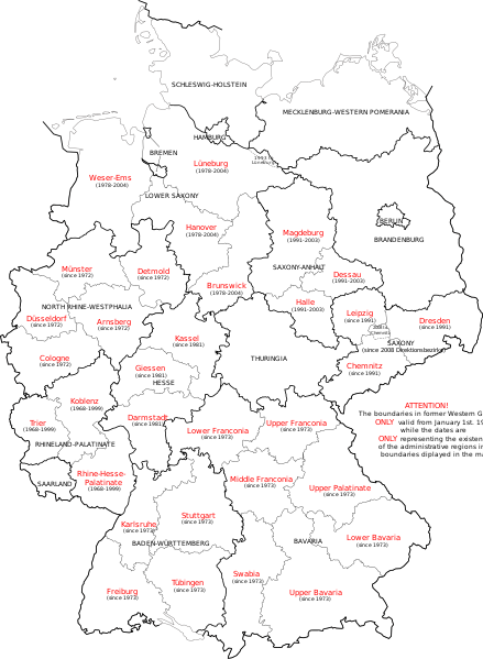
| 13:50, 30 September 2009 |  | 1,351 × 1,844 (1.39 MB) | Exec | {{Information |Description={{en|1=Map of Germany showing the boundaries of the Regierungsbezirke for FRG from January 1st 1981 and for Germany till 2008. Also displayed are the former RB of Lower Saxony, Rhineland-Palatinate and Saxony-Anhalt.}} |Source={ |
File usage
The following page uses this file:
Global file usage
The following other wikis use this file:
- Usage on ca.wikipedia.org
- Usage on et.wikipedia.org
- Usage on fr.wikipedia.org
- Usage on fy.wikipedia.org
- Usage on gv.wikipedia.org
- Usage on ia.wikipedia.org
- Usage on ku.wikipedia.org
- Usage on ms.wikipedia.org
- Usage on th.wikipedia.org
- Usage on uk.wikipedia.org
- Usage on www.wikidata.org
- Usage on zh.wikipedia.org

