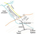
File:Abergynolwyn Village Incline Map.png
Appearance

Size of this preview: 639 × 600 pixels. Other resolutions: 256 × 240 pixels | 511 × 480 pixels | 818 × 768 pixels | 1,125 × 1,056 pixels.
Original file (1,125 × 1,056 pixels, file size: 213 KB, MIME type: image/png)
File history
Click on a date/time to view the file as it appeared at that time.
| Date/Time | Thumbnail | Dimensions | User | Comment | |
|---|---|---|---|---|---|
| current | 17:21, 18 March 2008 |  | 1,125 × 1,056 (213 KB) | Gwernol | {{Information |Description=Map of the Abergynolwyn village incline and branch, Talyllyn Railway |Source=self-made |Date=3/18/08 |Author= Gwernol |Permission=Public domain |other_versions= }} |
| 20:53, 11 March 2008 |  | 1,125 × 1,062 (211 KB) | Gwernol | {{Information |Description=Map of the village branch, Abergynolwyn, Talyllyn Railway |Source=self-made |Date=3/11/08 |Author= Gwernol |Permission=Public domain |other_versions= }} | |
| 14:00, 11 March 2008 |  | 1,200 × 1,044 (160 KB) | Gwernol | {{Information |Description=Map of the Abergynolwyn Village Branch, Talyllyn Railway |Source=self-made |Date=3/11/08 |Author= Gwernol |Permission=Public domain |other_versions= }} | |
| 12:36, 11 March 2008 |  | 979 × 825 (103 KB) | Gwernol | {{Information |Description=Map of the Abergynolwyn Village Branch |Source=self-made |Date=3/11/08 |Author= Gwernol |Permission=Public domain |other_versions= }} |
File usage
The following page uses this file:
