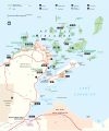
File:APISmap1.svg
Appearance

Size of this PNG preview of this SVG file: 504 × 599 pixels. Other resolutions: 202 × 240 pixels | 404 × 480 pixels | 646 × 768 pixels | 861 × 1,024 pixels | 1,723 × 2,048 pixels | 922 × 1,096 pixels.
Original file (SVG file, nominally 922 × 1,096 pixels, file size: 1,011 KB)
File history
Click on a date/time to view the file as it appeared at that time.
| Date/Time | Thumbnail | Dimensions | User | Comment | |
|---|---|---|---|---|---|
| current | 22:12, 25 June 2008 |  | 922 × 1,096 (1,011 KB) | MissMJ | Oh, bloody cropping. |
| 22:10, 25 June 2008 |  | 1,455 × 1,597 (1,013 KB) | MissMJ | Making it nominally larger. Maybe getting rid of purple lines? | |
| 05:19, 22 June 2008 |  | 918 × 1,099 (1,013 KB) | MissMJ | cropped | |
| 05:17, 22 June 2008 |  | 1,455 × 1,179 (1,014 KB) | MissMJ | {{Information |Description={{en|1=Park map produced by the National Park Service of the Apostle Islands National Lakeshore, on the Wisconsion south shore of Lake Superior. Located in Bayfeild and Ashland Counties, Wisconsin.}} |Source=http://www.nps.gov/a |
File usage
The following page uses this file:
Global file usage
The following other wikis use this file:
- Usage on cs.wikipedia.org
- Usage on fr.wikipedia.org
- Usage on ru.wikipedia.org

