
File:A602development.png

Size of this preview: 800 × 564 pixels. Other resolutions: 320 × 225 pixels | 640 × 451 pixels | 907 × 639 pixels.
Original file (907 × 639 pixels, file size: 339 KB, MIME type: image/png)
| This is a file from the Wikimedia Commons. Information from its description page there is shown below. Commons is a freely licensed media file repository. You can help. |
Summary
| Description |
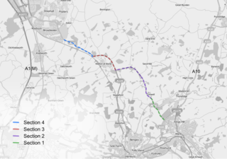
English: A map showing the proposed and accepted developments on the A602 between Stevenage and Ware. |
|||
| Date | ||||
| Source |
Own work work over wikipedia:Openstreetmap data
|
|||
| Author | EricITOworld | |||
| Other versions | file:A602development.svg |
Licensing
I, the copyright holder of this work, hereby publish it under the following licenses:
This file is licensed under the Creative Commons Attribution-Share Alike 3.0 Unported license.
- You are free:
- to share – to copy, distribute and transmit the work
- to remix – to adapt the work
- Under the following conditions:
- attribution – You must give appropriate credit, provide a link to the license, and indicate if changes were made. You may do so in any reasonable manner, but not in any way that suggests the licensor endorses you or your use.
- share alike – If you remix, transform, or build upon the material, you must distribute your contributions under the same or compatible license as the original.

|
Permission is granted to copy, distribute and/or modify this document under the terms of the GNU Free Documentation License, Version 1.2 or any later version published by the Free Software Foundation; with no Invariant Sections, no Front-Cover Texts, and no Back-Cover Texts. A copy of the license is included in the section entitled GNU Free Documentation License. |
You may select the license of your choice.
File history
Click on a date/time to view the file as it appeared at that time.
| Date/Time | Thumbnail | Dimensions | User | Comment | |
|---|---|---|---|---|---|
| current | 15:05, 30 November 2009 | | 907 × 639 (339 KB) | EricITOworld | cropped empty space to left of image. |
| 15:03, 30 November 2009 |  | 971 × 690 (354 KB) | EricITOworld | Though work was set to be undertaken in 2007 it never was, leaving the whole stretch still awaiting development. Map has been updated to reflect this, changing a portion of section 2 from worked upon to awaiting work. | |
| 12:47, 3 November 2009 |  | 913 × 638 (358 KB) | EricITOworld | {{Information |Description={{en|1=A map showing the proposed and accepted developments on the A602 between Stevenage and Ware.}} |Source={{own}} work over wikipedia:Openstreetmap data |Author=EricITOworld |Date=2009-11-02 |Permis |
File usage
The following 2 pages use this file: