Jump to content

File:22 West - Washington, D.C..jpg

Page contents not supported in other languages.
This is a file from the Wikimedia Commons
From Wikipedia, the free encyclopedia

Original file (2,289 × 2,150 pixels, file size: 3.48 MB, MIME type: image/jpeg)

Summary

Description
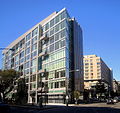
English: Facing west on M Street, N.W., – near the intersection of 22nd Street, M Street, and New Hampshire Avenue – in the West End neighborhood of Washington, D.C.

22 West (left), a 92-unit, 11-story, luxury condominium, was built by real estate developer Anthony Lanier of EastBanc, Inc. Designed by the architectural firm Shalom Baranes Associates, 22 West is the city's first residential building to feature a zinc-and-glass facade. The $120 million project was completed in 2008.

The Ritz-Carlton, Washington, D.C., (background) is a 300-room, 11-story, Five Diamond Ritz-Carlton hotel built in 2000. The adjoining, 162-unit condominium, The Residences at The Ritz-Carlton, Washington, D.C., – another property designed by Shalom Baranes Associates – is home to several notable individuals, including U.S. Senate Majority Leader Harry Reid.
Date
Source Own work
Author AgnosticPreachersKid
Permission
(Reusing this file)
I, the copyright holder of this work, hereby publish it under the following license:
w:en:Creative Commons
attribution share alike
This file is licensed under the Creative Commons Attribution-Share Alike 3.0 Unported license.
You are free:
  • to share – to copy, distribute and transmit the work
  • to remix – to adapt the work
Under the following conditions:
  • attribution – You must give appropriate credit, provide a link to the license, and indicate if changes were made. You may do so in any reasonable manner, but not in any way that suggests the licensor endorses you or your use.
  • share alike – If you remix, transform, or build upon the material, you must distribute your contributions under the same or compatible license as the original.
Camera location38° 54′ 19.58″ N, 77° 02′ 49.59″ W Kartographer map based on OpenStreetMap.View this and other nearby images on: OpenStreetMapinfo

Captions

Add a one-line explanation of what this file represents

Items portrayed in this file

depicts

15 September 2008

38°54'19.58"N, 77°2'49.60"W

0.004 second

5.7 millimetre

image/jpeg

57fd238b3dcfaa8d1a989550da725eafe3e0a292

3,649,321 byte

2,150 pixel

2,289 pixel

File history

Click on a date/time to view the file as it appeared at that time.

Date/TimeThumbnailDimensionsUserComment
current13:28, 21 February 2009Thumbnail for version as of 13:28, 21 February 20092,289 × 2,150 (3.48 MB)APK{{Information |Description={{en|1=The intersection of New Hampshire Avenue and M Street, NW in the West End neighborhood of Washington, D.C. The building in the foreground is [http://www.22west-dc.com/ 22 West] and in the background is the [http://www.rit

The following page uses this file:

Metadata