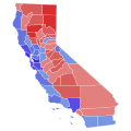
File:2022 United States Senate election in California results map by county.svg
Appearance

Size of this PNG preview of this SVG file: 600 × 600 pixels. Other resolutions: 240 × 240 pixels | 480 × 480 pixels | 768 × 768 pixels | 1,024 × 1,024 pixels | 2,048 × 2,048 pixels | 810 × 810 pixels.
Original file (SVG file, nominally 810 × 810 pixels, file size: 63 KB)
File history
Click on a date/time to view the file as it appeared at that time.
| Date/Time | Thumbnail | Dimensions | User | Comment | |
|---|---|---|---|---|---|
| current | 07:45, 24 January 2024 |  | 810 × 810 (63 KB) | Putitonamap98 | shapes |
| 23:16, 5 June 2023 |  | 744 × 744 (596 KB) | Wei-On Yeo | Reverted to version as of 23:35, 9 May 2023 (UTC). Sacramento County is just below 60%, still meaning it's in the 50-60% range. | |
| 01:11, 1 June 2023 |  | 744 × 744 (596 KB) | Kart2401real | Fixed Saacramento | |
| 23:35, 9 May 2023 |  | 744 × 744 (596 KB) | Wei-On Yeo | Fixed ocean border for Santa Barabra County | |
| 23:05, 9 May 2023 |  | 744 × 744 (611 KB) | Wei-On Yeo | updated final | |
| 11:42, 23 November 2022 |  | 744 × 744 (595 KB) | Elli | Uploaded own work with UploadWizard |
File usage
The following 4 pages use this file:
Global file usage
The following other wikis use this file:
- Usage on de.wikipedia.org
- Usage on ja.wikipedia.org
- Usage on ru.wikipedia.org
- Usage on zh.wikipedia.org

