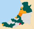
File:2022 Ceredigion County Council election map.png
Appearance

Size of this preview: 717 × 600 pixels. Other resolutions: 287 × 240 pixels | 574 × 480 pixels | 918 × 768 pixels | 1,200 × 1,004 pixels.
Original file (1,200 × 1,004 pixels, file size: 128 KB, MIME type: image/png)
File history
Click on a date/time to view the file as it appeared at that time.
| Date/Time | Thumbnail | Dimensions | User | Comment | |
|---|---|---|---|---|---|
| current | 03:19, 7 May 2022 |  | 1,200 × 1,004 (128 KB) | Woodgreener | Corrected Melindwr to PC and Mwldan to LD. |
| 02:40, 7 May 2022 |  | 1,200 × 1,004 (129 KB) | Woodgreener | {{Information |description={{en|1=Map of Ceredigion, Wales, UK showing the results of the 2022 local election. Colours: {{legend|#005B54|Plaid Cymru}} {{legend|#DDDDDD|Independents}} {{legend|#FAA61A|Liberal Democrats}} {{legend|#ff8000|Gwlad}} {{legend|#E4003B|Labour}}}} |date=2022-05-07 |source=Ordnance Survey [https://www.ordnancesurvey.co.uk/opendatadownload/products.html OpenData]. *Shape data from Boundary-Line product... |
File usage
The following page uses this file:
