Jump to content

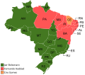
File:2018 Brazilian presidential election map (Round 1).svg

Page contents not supported in other languages.
This is a file from the Wikimedia Commons
From Wikipedia, the free encyclopedia

Original file (SVG file, nominally 613 × 539 pixels, file size: 1.6 MB)

Brazilian presidential election maps
1894 · 1898 · 1902 · 1906 · 1910 · 1914 · 1918 · 1919 1922 · 1926 · 1930 · 1945 · 1950 · 1955 · 1960
First round - Primeiro turno
1989 · 1994 · 1998 · 2002 · 2006 · 2010 · 2014 · 2018 · 2022
Second round - Segundo turno
1989 · 2002 · 2006 · 2010 · 2014 · 2018 · 2022
Vice presidential - Vice-presidencial
1950 · 1955 · 1960

Summary

Description
English: Results by state, Brazilian Presidential Election 2018, 1st round map
Português: Resultado por estados das eleições presidenciais brasileiras de 2018 no primeiro turno
Date
Source Adapted from: https://commons.wikimedia.org/wiki/File:2014_Brazilian_presidential_election_map_(Round_1).svg
Author Source: Felipe Menegaz;
Source 2: Marcos Júnior
Derivate work: Paladinum2
Other versions Alternative colour:
 
This W3C-unspecified vector image was created with Inkscape .

Licensing

w:en:Creative Commons
attribution share alike
This file is licensed under the Creative Commons Attribution-Share Alike 3.0 Unported license.
You are free:
  • to share – to copy, distribute and transmit the work
  • to remix – to adapt the work
Under the following conditions:
  • attribution – You must give appropriate credit, provide a link to the license, and indicate if changes were made. You may do so in any reasonable manner, but not in any way that suggests the licensor endorses you or your use.
  • share alike – If you remix, transform, or build upon the material, you must distribute your contributions under the same or compatible license as the original.

Captions

Add a one-line explanation of what this file represents

Items portrayed in this file

depicts

15 October 2018

image/svg+xml

5c7245fa882a509d88b108dd5ef4315139ac68e0

1,674,942 byte

539 pixel

613 pixel

File history

Click on a date/time to view the file as it appeared at that time.

Date/TimeThumbnailDimensionsUserComment
current16:20, 28 April 2020Thumbnail for version as of 16:20, 28 April 2020613 × 539 (1.6 MB)Paladinum2adding portuguese word "Exterior" with abroad brazilians votes for brazilians understand. Also moving AC and DF to more readable places
02:31, 17 October 2018Thumbnail for version as of 02:31, 17 October 2018613 × 539 (685 KB)Paladinum2Less brighter colours, same PT colour of older elections maps
16:57, 15 October 2018Thumbnail for version as of 16:57, 15 October 2018613 × 539 (685 KB)Paladinum2Changing Ciro Gomes colour, due the other eletcions' maps PDT party colour
16:36, 15 October 2018Thumbnail for version as of 16:36, 15 October 2018613 × 539 (685 KB)Paladinum2User created page with UploadWizard

The following page uses this file:

Global file usage

The following other wikis use this file:

Metadata