Jump to content

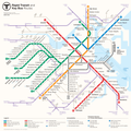
File:2013 unofficial MBTA subway map by Michael Kvrivishvili.png

Page contents not supported in other languages.
This is a file from the Wikimedia Commons
From Wikipedia, the free encyclopedia

Original file (3,300 × 3,300 pixels, file size: 1.35 MB, MIME type: image/png)

Description

An unofficial redesign of the MBTA subway map, created for a contest held by the MBTA in 2013. A slightly modified version won the contest; a further modified version has been adopted as the official MBTA subway map.

The designer's comments on his map:

Re-design of the rapid transit/key bus routes T map. Designed in accordance to MBTA design standards. To simplify an overall impression of the map, I designed it from the scratch, based on set of strict rules. The aim was to create clear, easily readable and usable diagram, representing quite complicated system in as simple form as possible. There was no intention to mimic any particular visual style — in my design form follows function. This approach created some artifacts as a result, like capital B at the heart of the map, or "wing" of Green Line branches. Map still needs some work: water should be smoother and map should incorporate information on walking distances, specially in downtown.
Date
Source Flickr: Boston Rapid Transit Map
Author Michael Kvrivishvili
Permission
(Reusing this file)
This image, which was originally posted to Flickr, was uploaded to Commons using Flickr upload bot on 28 September 2013, 17:00 by Pi.1415926535. On that date, it was confirmed to be licensed under the terms of the license indicated.
w:en:Creative Commons
attribution
This file is licensed under the Creative Commons Attribution 2.0 Generic license.
You are free:
  • to share – to copy, distribute and transmit the work
  • to remix – to adapt the work
Under the following conditions:
  • attribution – You must give appropriate credit, provide a link to the license, and indicate if changes were made. You may do so in any reasonable manner, but not in any way that suggests the licensor endorses you or your use.

Captions

Add a one-line explanation of what this file represents

Items portrayed in this file

depicts

14 May 2013

image/png

1f78809daaecf7e8b279676b0f9d6f46c2eed9b8

1,413,650 byte

3,300 pixel

3,300 pixel

42°21'47"N, 71°3'25"W

File history

Click on a date/time to view the file as it appeared at that time.

Date/TimeThumbnailDimensionsUserComment
current12:59, 2 May 2019Thumbnail for version as of 12:59, 2 May 20193,300 × 3,300 (1.35 MB)World MetroReverted to version as of 17:00, 28 September 2013 (UTC) I've been thinking and have realized that the other two would be better as their own files instead of a version of this one.
15:21, 26 April 2019Thumbnail for version as of 15:21, 26 April 20191,550 × 1,550 (9.19 MB)World MetroOr, if you prefer, this even more graphically better one. Tell me, is it not the best photoshop work you've ever seen?
15:07, 26 April 2019Thumbnail for version as of 15:07, 26 April 20191,550 × 1,550 (9.19 MB)World MetroNo no no use this one it's the one from Boston.com's article about the competition finalists and it's much better because the 1 bus is straight and it shows the whole Needham Line.
17:00, 28 September 2013Thumbnail for version as of 17:00, 28 September 20133,300 × 3,300 (1.35 MB)Flickr upload botUploaded from http://flickr.com/photo/10247460@N03/8737231765 using Flickr upload bot

The following 2 pages use this file:

Global file usage

The following other wikis use this file:

Metadata