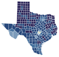
File:2005 Texas Proposition 2 results map by county.svg
Appearance

Size of this PNG preview of this SVG file: 630 × 600 pixels. Other resolutions: 252 × 240 pixels | 504 × 480 pixels | 807 × 768 pixels | 1,076 × 1,024 pixels | 2,152 × 2,048 pixels | 744 × 708 pixels.
Original file (SVG file, nominally 744 × 708 pixels, file size: 1.1 MB)
File history
Click on a date/time to view the file as it appeared at that time.
| Date/Time | Thumbnail | Dimensions | User | Comment | |
|---|---|---|---|---|---|
| current | 07:23, 11 May 2023 |  | 744 × 708 (1.1 MB) | Tinpo162 | Reverted to version as of 02:25, 26 March 2021 (UTC) |
| 06:50, 19 September 2021 |  | 744 × 708 (1.1 MB) | Fluffy89502 | stroke | |
| 02:25, 26 March 2021 |  | 744 × 708 (1.1 MB) | Awmcphee | Fixed that one county | |
| 02:23, 26 March 2021 |  | 744 × 708 (1.1 MB) | Awmcphee | Standardized geography | |
| 03:55, 23 March 2021 |  | 322 × 315 (132 KB) | Awmcphee | Got my own gdang color scheme backwards!!!! This is just for consistency between all states. | |
| 03:53, 23 March 2021 |  | 322 × 315 (132 KB) | Awmcphee | Colorblind friendly palette. | |
| 01:33, 8 June 2013 |  | 322 × 315 (139 KB) | CentrumZero | User created page with UploadWizard |
File usage
The following page uses this file:

