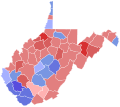
File:1996 West Virginia gubernatorial election results map by county.svg
Appearance

Size of this PNG preview of this SVG file: 675 × 599 pixels. Other resolutions: 270 × 240 pixels | 541 × 480 pixels | 865 × 768 pixels | 1,154 × 1,024 pixels | 2,307 × 2,048 pixels | 810 × 719 pixels.
Original file (SVG file, nominally 810 × 719 pixels, file size: 38 KB)
File history
Click on a date/time to view the file as it appeared at that time.
| Date/Time | Thumbnail | Dimensions | User | Comment | |
|---|---|---|---|---|---|
| current | 06:22, 1 January 2024 |  | 810 × 719 (38 KB) | Putitonamap98 | shapes |
| 17:12, 11 January 2023 |  | 744 × 666 (363 KB) | Putitonamap98 | shapes | |
| 01:31, 13 June 2019 |  | 290 × 276 (19 KB) | Over9000edits | county percentage data from https://uselectionatlas.org/RESULTS/datagraph.php?year=1996&fips=54&f=0&off=5&elect=0 | |
| 03:58, 26 June 2016 |  | 290 × 276 (23 KB) | ExecutiveWashington | User created page with UploadWizard |
File usage
The following page uses this file:
