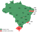
File:1989 Brazilian presidential election map (Round 2).svg
Appearance

Size of this PNG preview of this SVG file: 682 × 599 pixels. Other resolutions: 273 × 240 pixels | 546 × 480 pixels | 874 × 768 pixels | 1,166 × 1,024 pixels | 2,331 × 2,048 pixels | 2,000 × 1,757 pixels.
Original file (SVG file, nominally 2,000 × 1,757 pixels, file size: 476 KB)
File history
Click on a date/time to view the file as it appeared at that time.
| Date/Time | Thumbnail | Dimensions | User | Comment | |
|---|---|---|---|---|---|
| current | 16:26, 2 May 2015 |  | 2,000 × 1,757 (476 KB) | Cendes | correção |
| 16:06, 2 May 2015 |  | 2,000 × 1,757 (347 KB) | Cendes | Reverted to version as of 15:48, 2 May 2015 | |
| 16:05, 2 May 2015 |  | 2,000 × 1,757 (167 KB) | Cendes | correção nas cores | |
| 15:48, 2 May 2015 |  | 2,000 × 1,757 (347 KB) | Cendes | http://agencia.tse.jus.br/estatistica/sead/odsele/votacao_candidato_uf/votacao_candidato_uf_1989.zip - Lula só ganhou em RS, RJ, PE e DF | |
| 20:05, 30 October 2014 |  | 575 × 505 (682 KB) | Dilermando | + SC, BA e RN | |
| 19:22, 30 October 2014 |  | 575 × 505 (682 KB) | Dilermando | {{Information |Description ={{en|1=Results map of the 1989 Brazilian presidential election.}} {{pt|1=Mapa de resultados da [[:pt:Eleição presidencial no Brasil em 1989|Eleição presidencial no Brasil... |
File usage
The following page uses this file:
Global file usage
The following other wikis use this file:
- Usage on fi.wikipedia.org
- Usage on pt.wikipedia.org

