Jump to content

File:1927 BAKER HOUSES.png

Page contents not supported in other languages.
This is a file from the Wikimedia Commons
From Wikipedia, the free encyclopedia

1927_BAKER_HOUSES.png (474 × 447 pixels, file size: 381 KB, MIME type: image/png)

Summary

Description
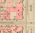
English: A map showing Lots 31, 33, and 35 (combined as lot 33, city block #1505) at the northwest corner of Park Avenue and 93rd Street, Manhattan, New York City. The conjoined buildings shown (from left clockwise): garage and staff quarters (#69 East 93rd St.); ballroom wing, and north annex (1190 Park Avenue); main house (1180 Park Avenue - aka 75 East 93rd St.) Lot 30 would soon be added to the complex.
Date
Source Lionel Pincus and Princess Firyal Map Division, The New York Public Library. "Plate 118, Part of Section 5" The New York Public Library Digital Collections. 1927. https://digitalcollections.nypl.org/items/43da2b40-2581-0132-c4ab-58d385a7b928
Author G. W. Bromley & Co.
Permission
(Reusing this file)
Public Domain

Licensing

Public domain
This work is in the public domain in the United States because it was published (or registered with the U.S. Copyright Office) before January 1, 1929.

Public domain works must be out of copyright in both the United States and in the source country of the work in order to be hosted on the Commons. If the work is not a U.S. work, the file must have an additional copyright tag indicating the copyright status in the source country.
Note: This tag should not be used for sound recordings.PD-1923Public domain in the United States//commons.wikimedia.org/wiki/File:1927_BAKER_HOUSES.png

Captions

Add a one-line explanation of what this file represents

Items portrayed in this file

depicts

image/png

444cf0545cb942d55308e6c73eb43818c308fe8e

390,137 byte

447 pixel

474 pixel

File history

Click on a date/time to view the file as it appeared at that time.

Date/TimeThumbnailDimensionsUserComment
current02:23, 15 January 2023Thumbnail for version as of 02:23, 15 January 2023474 × 447 (381 KB)Wackyboutwiki{{Information |Description= A map showing Lots 31, 33, and 35 (combined as lot 33, city block #1505) at the northwest corner of Park Avenue and 93rd Street, Manhattan, New York City. The conjoined buildings shown (from left clockwise): garage and staff quarters (#69 East 93rd St.); ballroom wing, and north annex (1190 Park Avenue); main house (1180 Park Avenue - aka 75 East 93rd St.) Lot 30 would soon be added to the complex. |Source= Lionel Pincus and Princess Firyal Map Division, The Ne...

The following page uses this file:

Metadata