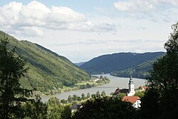
Engelhartszell an der Donau
Appearance
(Redirected from Engelhartszell)
Engelhartszell
Engöhoartszö | |
|---|---|
 | |
| Coordinates: 48°30′00″N 13°44′00″E / 48.50000°N 13.73333°E | |
| Country | Austria |
| State | Upper Austria |
| District | Schärding |
| Government | |
| • Mayor | Hannah Wundsam (ÖVP) |
| Area | |
• Total | 18.83 km2 (7.27 sq mi) |
| Elevation | 302 m (991 ft) |
| Population (2018-01-01)[2] | |
• Total | 942 |
| • Density | 50/km2 (130/sq mi) |
| Time zone | UTC+1 (CET) |
| • Summer (DST) | UTC+2 (CEST) |
| Postal code | 4090 |
| Area code | 07717 |
| Vehicle registration | SD |
| Website | www.engelhartszell.at |
Engelhartszell an der Donau (Central Bavarian: Engöhoartszö) is a municipality in the district of Schärding in the Austrian state of Upper Austria.
Geography
[edit]Engelhartszell lies in the upper Danube valley in the Innviertel. About 57 percent of the municipality is forest, and 28 percent is farmland.
Notable people
[edit]- Ingrid Nargang (1929–2019), lawyer and contemporary historian
References
[edit]- ^ "Dauersiedlungsraum der Gemeinden Politischen Bezirke und Bundesländer - Gebietsstand 1.1.2018". Statistics Austria. Retrieved 10 March 2019.
- ^ "Einwohnerzahl 1.1.2018 nach Gemeinden mit Status, Gebietsstand 1.1.2018". Statistics Austria. Retrieved 9 March 2019.
Wikimedia Commons has media related to Engelhartszell.


