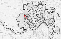
East Westwood, Cincinnati
East Westwood | |
|---|---|
 | |
| Country | United States |
| State | Ohio |
| City | Cincinnati |
| Population (2020) | |
• Total | 2,458 |
| Time zone | UTC-5 (EST) |
| • Summer (DST) | UTC-4 (EDT) |
East Westwood is one of the 52 neighborhoods of Cincinnati, Ohio. The population was 2,458 at the 2020 census.[1]
Demographics
[edit]| Year | Pop. | ±% | ||
|---|---|---|---|---|
| 2010 | 2,445 | — | ||
| 2020 | 2,458 | +0.5% | ||
| ||||
As of the census of 2020, there were 2,458 people living in the neighborhood. There were 1,438 housing units. The racial makeup of the neighborhood was 12.3% White, 79.9% Black or African American, 0.3% Native American, 0.4% Asian, 0.1% Pacific Islander, 2.1% from some other race, and 4.9% from two or more races. 2.5% of the population were Hispanic or Latino of any race.[1]
There were 1,431 households, out of which 56.4% were families. 37.9% of all households were made up of individuals.[1]
34.5% of the neighborhood's population were under the age of 18, 49.9% were 18 to 64, and 15.6% were 65 years of age or older. 58.8% of the population were male and 41.2% were female.[1]
According to the U.S. Census American Community Survey, for the period 2016-2020 the estimated median annual income for a household in the neighborhood was $20,929. About 48.5% of family households were living below the poverty line. About 3.4% had a bachelor's degree or higher.[1]

