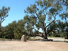
Durham, Queensland
| Durham Bulloo Shire, Queensland | |||||||||||||||
|---|---|---|---|---|---|---|---|---|---|---|---|---|---|---|---|
 Bullah Bullah waterhole, 2008 | |||||||||||||||
| Coordinates | 27°15′31″S 141°47′35″E / 27.2586°S 141.7930°E | ||||||||||||||
| Population | 31 (2021 census)[1] | ||||||||||||||
| • Density | 0.001650/km2 (0.00427/sq mi) | ||||||||||||||
| Postcode(s) | 4492 | ||||||||||||||
| Area | 18,789.4 km2 (7,254.6 sq mi) | ||||||||||||||
| Time zone | AEST (UTC+10:00) | ||||||||||||||
| LGA(s) | Bulloo Shire | ||||||||||||||
| State electorate(s) | Warrego | ||||||||||||||
| Federal division(s) | Maranoa | ||||||||||||||
| |||||||||||||||
Durham is a rural locality in the Shire of Bulloo, Queensland, Australia.[2] It is on the Queensland border with South Australia.[3] In the 2021 census, Durham had a population of 31 people.[1]
Geography
[edit]Cooper Creek passes north-south through the centre of the locality.
Three major outback roads pass through Durham:[4]
- Adventure Way to South Australia
- Bullo Developmental Road to Cunnamulla
- Cooper Developmental Road to Quilpie
History
[edit]The area is the traditional lands of the Yandruwandha people.
In the 17th century, Spain and Portugal divided the world between them with a line running through Durham, which eventually became the border with South Australia. No representatives of either empire visited the site and no consultation with the Yandruwandha people was ever under taken.
The first Europeans to the area were the various parties within the Burke and Wills expedition.
Demographics
[edit]In the 2016 census Durham had a population of 36 people.[5]
In the 2021 census, Durham had a population of 31 people.[1]
Heritage listings
[edit]
The heritage-listed Burke and Wills Dig Tree is located beside the Bullah Bullah Waterhole at the Nappa Merrie pastoral station (27°37′18″S 141°04′24″E / 27.6216°S 141.0734°E).[6]
Education
[edit]There are no schools in Durham and none nearby. Distance education and boarding school would be options.[3]
Economy
[edit]There are a number of homesteads in the locality:[7]
- Durham Downs (27°04′44″S 141°54′27″E / 27.0789°S 141.9075°E)
- Joes Outstation (26°55′48″S 141°47′31″E / 26.9300°S 141.7920°E)
- Kihee (27°23′17″S 142°37′13″E / 27.3880°S 142.6203°E)
- Nappa Merrie (27°35′46″S 141°06′24″E / 27.5962°S 141.1068°E)
- New Bundeena Outstation (27°22′48″S 142°35′37″E / 27.3800°S 142.5935°E)
- St Anne's Cottage (27°26′11″S 141°17′38″E / 27.4363°S 141.2940°E)
- Woomanooka (27°15′03″S 142°07′46″E / 27.2509°S 142.1295°E)
References
[edit]- ^ a b c Australian Bureau of Statistics (28 June 2022). "Durham (SAL)". 2021 Census QuickStats. Retrieved 28 February 2023.
- ^ "Durham – locality in Shire of Bulloo (entry 50022)". Queensland Place Names. Queensland Government. Retrieved 26 December 2020.
- ^ a b "Queensland Globe". State of Queensland. Retrieved 28 December 2023.
- ^ "Downs South West Region West" (PDF). Road region maps. Queensland Government. Archived from the original (PDF) on 17 May 2014. Retrieved 17 May 2014.
- ^ Australian Bureau of Statistics (27 June 2017). "Durham (SSC)". 2016 Census QuickStats. Retrieved 20 October 2018.
- ^ "Burke and Wills Dig Tree (entry 601073)". Queensland Heritage Register. Queensland Heritage Council. Retrieved 17 May 2014.
- ^ "Homesteads - Queensland". Queensland Open Data. Queensland Government. 18 November 2020. Archived from the original on 24 November 2020. Retrieved 24 November 2020.
External links
[edit]![]() Media related to Durham, Queensland at Wikimedia Commons
Media related to Durham, Queensland at Wikimedia Commons

