Umm Ubayda
Appearance
(Redirected from Draft:Umm Ubayda)
Umm ‘Ubayda
ام عبيدة | |
|---|---|
Village | |
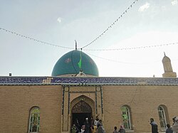
 Tomb of Ahmad al-Rifa'i in Umm Ubayda | |
| Coordinates: 31°41′43″N 46°40′23″E / 31.69531°N 46.67298°E[1] | |
| Country | Iraq |
| Governorate | Maysan |
| Elevation | 9 m (30 ft) |
| Time zone | UTC+3 (Arabian Standard Time) |
Umm ‘Ubayda Arabic: ام عبيدة, also spelled Umm ‘Abida, is a village in Al-Maimouna District of Maysan Governorate, Iraq.[1] Located in the marshy Batihah region of southern Iraq, it is known for being the home and burial site of the 12th-century Sufi saint Ahmad al-Rifa'i, the eponymous founder of the Rifa'i Sufi order.[2][3][4] Ibn Battuta visited Umm Ubayda in 1327. He wrote that the Rifa'i community had a large ribat there at the time, home to "thousands" of dervishes.[2][4]
References
[edit]- ^ a b c "Geonames.org. Markaz Nāḩiyat Umm 'Ubaydah". Retrieved 28 November 2020.
- ^ a b Abun-Nasr, Jamil M. (2007). Muslim Communities of Grace: The Sufi Brotherhoods in Islamic Religious Life. New York & Chichester: Columbia University Press. p. 122. ISBN 978-0-231-51279-4. Retrieved 29 November 2020.
- ^ Biegman, Nicolaas H. (2009). Living Sufism: Rituals in the Middle East and the Balkans. Cairo & New York: American University of Cairo Press. p. 21. ISBN 978-977-416-263-3. Retrieved 29 November 2020.
- ^ a b Campo, Juan Eduardo, ed. (2009). Encyclopedia of Islam. New York: Facts On File. pp. 592–93. ISBN 978-0-8160-5454-1. Retrieved 29 November 2020.

