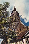
St. Ansgarii Church

St. Ansgarii Church was a medieval Brick Gothic church in Bremen. The 97-meter-high tower was the tallest landmark of the city for centuries. The church was the starting point of the Reformation in Bremen. The building was severely damaged during World War II and the ruin was demolished in the 1950s. A new church building under the same name was constructed outside of the old city.
History
[edit]The name and tradition of St. Ansgarii go back to around 850, when Archbishop Ansgar of Bremen, known as the "Apostle of the North", established a foundation for twelve clergy here. Ansgar was later buried in Bremen in 865. In the late 12th century, Archbishop Hartwig II set up a collegiate monastery with twelve canons, with the task of building a basilica in honor of St. Ansgar. This original Brick Gothic parish church was consecrated in 1243 and converted into a hall church at the end of the 14th century. The main tower on the west side was not completed until the 14th century. After a fire in 1590, a canopy was added to the top and the tower reached its final height of about 97 meters.[1]
A sermon by the Dutch Augustinian friar Heinrich von Zütphen, a colleague of Martin Luther, in the Ansgarii church was the starting point for the Reformation in Bremen in 1522 emphasizing the theological and historical importance of the St. Ansgarii community for the history of Bremen.[2]

The tower steeple, the tallest in the city, was used as the center point for the first Bremen land survey in 1797 and served mathematician Carl Friedrich Gauß for further triangulation surveys in 1824. These events are commemorated on a metal plaque on the "Ansgarikirchhof" city square.[3][4]
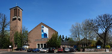
The church was severely damaged in the air raids on Bremen during World War II. The main tower collapsed on September 1, 1944, and damaged further elements of the church.[5] The ruin was demolished in the 1950s and the "Bremer Carreé" city block and shopping center was built in its place.[6] A new church building under the same name was constructed in 1955–57 in the outer city district of Schwachhausen, serving as the new center for the Ansgarii church community. Some elements of the medieval church like the pulpit and elaborate stone epitaphs survived and were placed inside the new church building.[7]
The memorial "Ansgar column" was installed in 1965 on the "Ansgarikirchhof" city square in honor of the 1100th anniversary of the death of St. Ansgar and in memory of the destruction of St. Ansgarii church in 1944. The bronze column forms a Bible, ship and cross: the symbols of Ansgar's mission.[8]
A group of citizens formed the committee "Anschari e.V. - Association for the historical cityscape of Bremen" which promotes the reconstruction of the Ansgarii Church and the demolition of the "Bremer Carreé" city block that was built in its place.[9]
-
Bell tower in the 1930s
-
Floor plan of the medieval construction
-
Surviving wooden pulpit
-
Plaque for land surveys 1797 & 1824
-
"Ansgar column" from 1965
-
Modern church built in the 1950s
Further reading
[edit]- Herbert Schwarzwälder: Das Große Bremen-Lexikon. 2., aktualisierte, überarbeitete und erweiterte Auflage. Edition Temmen, Bremen 2003, ISBN 3-86108-693-X
- Siegried Fliedner: Zur Baugeschichte der Pfarrkirchen St. Martini und St. Ansgarii in Bremen. In Bremisches Jahrbuch, 44. Band, pp. 306–317, Schünemann Verlag, Bremen 1955, ISBN 978-1247874302
- Uwe Pape and Winfried Topp: Orgeln und Orgelbauer in Bremen., pp. 291–296, Pape Verlag, Berlin 1998, ISBN 3-921140-52-8
References
[edit]- ^ Herbert Schwarzwälder: Das Große Bremen-Lexikon 2nd edition. Temmen, Bremen 2003, ISBN 3-86108-693-X
- ^ Henneke Gülzow (1969), "Heinrich von Zütphen", Neue Deutsche Biographie (in German), vol. 8, Berlin: Duncker & Humblot, pp. 431–431; (full text online)
- ^ Kittel, C., Knight, W.D., Ruderman, M.A., Helmholz, A.C., Moyer, B.J.: Mechanik. Springer, Berlin / Heidelberg 2001, ISBN 978-3-540-41569-5 [1], p. 5, at Google Books
- ^ Landesamt für Geoinformation und Landesvermessung Niedersachsen. "Gaußsche Landesaufnahme (GL)". Historische Karten. Retrieved 2020-09-06.
- ^ Bildarchiv Foto Marburg. "Ehemalige Evangelische Pfarrkirche Sankt Ansgarii". Bildindex. Philipps-Universität Marburg. Retrieved 2020-09-06.
- ^ Bremer Carreé: Ansgarihaus that replaced the original Ansgarii church
- ^ Landesamt für Denkmalpflege. "St. Ansgarii-Kirche". Denkmaldatenbank. Retrieved 2020-09-06.
- ^ Senator für Kultur Bremen. ""Ansgar-Säule" 1965". Kunst im öffentlichen Raum Bremen. Retrieved 2020-09-06.
- ^ Hethey, F. (2016-08-30). "Committee promotes the reconstruction of the Ansgarii church (in German)". Weser-Kurier. Retrieved 2020-09-06.
External links
[edit]- Destroyed churches in Germany
- Demolished buildings and structures in Germany
- Lutheran churches converted from Roman Catholicism
- Buildings and structures in Germany destroyed during World War II
- Churches in Bremen (city)
- Protestant churches in Bremen (state)
- Buildings and structures completed in 1243
- Churches completed in the 1240s
- Buildings and structures demolished in the 1950s
- 13th-century churches in Germany


