Kutri
This article possibly contains original research. (March 2020) |
Kutri | |
|---|---|
Village | |
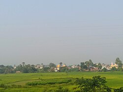
 Panorama View of Kutri | |
| Coordinates: 25°01′23″N 85°36′08″E / 25.023060°N 85.602250°E | |
| Country | |
| State | Bihar |
| District | Nawada |
| Government | |
| • Type | Panchayati raj (India) |
| • Body | Gram panchayat |
| Population (2011) | |
| • Total | 5,445[1] |
| Languages | |
| • Official | Hindi |
| Time zone | UTC+5:30 (IST) |
| Postal Index Number | 805130[2] |
| Telephone code | 06325[2] |
| Vehicle registration | BR-27-XXXX |
| Website | nawada |
Kutri Village (Census of India Village-code 257586) is located in the Warisaliganj Block of Nawada district in Bihar, India. It is a historical village among 80 villages of Warisaliganj Block of Nawada district. According to government records, Kutri village has 842 houses spread over a geographical area of 368 hectares. It is situated 5 km away from the Warisaliganj Block and 22 km away from Nawada. As of 2009, Kutri village was designated a gram panchayat.[3][1]
Kutri gram panchayat
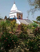
[edit]The gram panchayat is a "village of temples" and the villagers venerate Aadi Shakti, Maa Kali, and Shiva. The largest pond by the southwest corner of the temple to Shiva in the village is a reminder of the village as the historical symbol of Kashi City. The village was a prominent place of Hindu dharma in ancient ages.[4]
Kutri Panchayat consists of the following villages: Kutri, Naromurar, Khirbhojna, and Rampur
Kutri is a Magadh village that is 120 km away from Bihar state's capital city Patna and approximately 20 km from Rajgriha, a capital city during the Magadh dynasty. In the era of the Magadh Dynasty, the administration was strong and the village had a local chief known as the gramakas. Its administration was divided into executive, judiciary, and military divisions. In the Mughal & British era during the Zamindari system, a similar form of administration called kachahari (A tax collection and judiciary system) was practiced in Naromurar—a village of Kutri Panchayat and was headed by Zamindar under Mahalwari system of the British empire. Therefore, ancient Kutri villages were equipped with a systematic administration system but also surrounded by various historical and tourist centres such as Rajgrih, Nalanda, Pawapuri, Kakolat, Silao, Gaya, and Patliputra. Its presence in the centre of these places makes it a good tourist centre with the importance of reminding intact of Hindu religion while the region was undergoing a transition of religious belief from Vedic Ahinsa parmo dharma. Buddhism and Jainism flourished in this region during ancient times with Nalanda University was the centre of education during the Magadh & contemporary Gupta empire, which was a Brahmin dynasty. Kutri has five sub-villages: Naromurar, Khirbhojna, Rampur, Tullapur, and Masankhama. Kutri & Naromurar inhabitants are Bhumihar, Brahmins and Maithil Brahmins.[citation needed]

Language
[edit]The primary languages used in Kutri are Magahiin the Nawada District and Hindiin Magadh Division of Bihar.[5]
Geography
[edit]Climate
[edit]The table below shows historical monthly averages for climate variables in Kutri.
| Climate data for Patna Airport (1981–2010, extremes 1951–2012) | |||||||||||||
|---|---|---|---|---|---|---|---|---|---|---|---|---|---|
| Month | Jan | Feb | Mar | Apr | May | Jun | Jul | Aug | Sep | Oct | Nov | Dec | Year |
| Record high °C (°F) | 30.0 (86.0) |
35.1 (95.2) |
41.4 (106.5) |
44.6 (112.3) |
45.6 (114.1) |
46.6 (115.9) |
41.2 (106.2) |
39.7 (103.5) |
37.5 (99.5) |
37.2 (99.0) |
34.1 (93.4) |
30.5 (86.9) |
46.6 (115.9) |
| Mean daily maximum °C (°F) | 22.4 (72.3) |
26.0 (78.8) |
32.2 (90.0) |
37.0 (98.6) |
37.4 (99.3) |
36.4 (97.5) |
33.0 (91.4) |
32.9 (91.2) |
32.5 (90.5) |
31.9 (89.4) |
29.0 (84.2) |
24.5 (76.1) |
31.3 (88.3) |
| Mean daily minimum °C (°F) | 9.3 (48.7) |
12.1 (53.8) |
16.7 (62.1) |
22.1 (71.8) |
25.1 (77.2) |
26.7 (80.1) |
26.3 (79.3) |
26.3 (79.3) |
25.5 (77.9) |
21.5 (70.7) |
15.1 (59.2) |
10.5 (50.9) |
19.8 (67.6) |
| Record low °C (°F) | 1.4 (34.5) |
3.4 (38.1) |
8.2 (46.8) |
13.3 (55.9) |
17.7 (63.9) |
19.3 (66.7) |
21.1 (70.0) |
20.5 (68.9) |
19.0 (66.2) |
12.0 (53.6) |
7.7 (45.9) |
2.2 (36.0) |
1.4 (34.5) |
| Average rainfall mm (inches) | 11.1 (0.44) |
14.0 (0.55) |
9.5 (0.37) |
12.7 (0.50) |
43.7 (1.72) |
162.5 (6.40) |
354.4 (13.95) |
277.8 (10.94) |
197.7 (7.78) |
49.1 (1.93) |
7.2 (0.28) |
6.1 (0.24) |
1,145.8 (45.11) |
| Average rainy days | 1.2 | 1.3 | 0.7 | 1.0 | 2.9 | 6.9 | 14.3 | 12.5 | 9.5 | 2.9 | 0.5 | 0.6 | 54.2 |
| Average relative humidity (%) (at 17:30 IST) | 65 | 52 | 37 | 32 | 42 | 59 | 75 | 75 | 76 | 68 | 67 | 69 | 60 |
| Mean monthly sunshine hours | 207.7 | 228.8 | 260.4 | 264.0 | 272.8 | 192.0 | 130.2 | 151.9 | 162.0 | 238.7 | 240.0 | 201.5 | 2,550 |
| Mean daily sunshine hours | 6.7 | 8.1 | 8.4 | 8.8 | 8.8 | 6.4 | 4.2 | 4.9 | 5.4 | 7.7 | 8.0 | 6.5 | 7.0 |
| Source: India Meteorological Department (sun 1971–2000)[6][7][8] | |||||||||||||
Education
[edit]
As a Magadha Empire village, Kutri has had Vedic education and the judiciary system in ancient times. Nalanda University, an Indian educational institution, is situated near Kutri. During the British Raj, school education started in the 1900s with the establishment of Middle School Kutri in the north of the village. Siya Saran Singh – a teacher of Kochgaon, contributed in proliferating education in Kutri. With Harvansh Kumari's support, they built a primary school of 3 rooms during the Zamindari system. The school was later extended to middle school up to class 7. After Indian independence, Kutri villagers began to attend the BK Sahoo High School at Warisaliganj. It was decided in Oct 1972 during the Durga Puja Festival that a high school was required. It was difficult for girls to get higher education due to the unavailability of high school in nearby locations. In December 1978, Kutri High School became a government-approved high school and is now an inter-high school. Apart from this, there were some coaching classes run privately. Currently, there is one middle school and one inter-high school in the village where students from nearby villages including Naromurar, Gorapar, Lohrajpur and Paingari, come for education.[9]
See also
[edit]References
[edit]- ^ a b "Nawada District Census Handbook Page No. 3 for Population and Page No. 76 for Village Code" (PDF).
- ^ a b "Postal Code (PIN) and STD Code".
- ^ "Details of Blocks and Villages of Nawada District".
- ^ "Panchayat and Village Details of Nawada" (PDF).
- ^ Frawley, William (May 2003). International Encyclopedia of Linguistics: 4-Volume Set By William Frawley. ISBN 9780195139778.
- ^ "Station: Patna Climatological Table 1981–2010" (PDF). Climatological Normals 1981–2010. India Meteorological Department. January 2015. pp. 601–602. Archived from the original (PDF) on 5 February 2020. Retrieved 2 March 2020.
- ^ "Extremes of Temperature & Rainfall for Indian Stations (Up to 2012)" (PDF). India Meteorological Department. December 2016. p. M36. Archived from the original (PDF) on 5 February 2020. Retrieved 2 March 2020.
- ^ "Table 3 Monthly mean duration of Sun Shine (hours) at different locations in India" (PDF). Daily Normals of Global & Diffuse Radiation (1971–2000). India Meteorological Department. December 2016. p. M-3. Archived from the original (PDF) on 5 February 2020. Retrieved 2 March 2020.
- ^ "Higher Secondary School List SL. No. 64".


