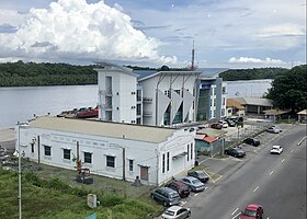
Kuala Belait Port
| Kuala Belait Port | |
|---|---|
 Kuala Belait Port in 2020 | |
 Click on the map for a fullscreen view | |
| Location | |
| Country | Brunei |
| Location | Kuala Belait, Belait |
| Coordinates | 4°34′55″N 114°11′26″E / 4.5818942°N 114.1904280°E |
| Details | |
| Operated by | Maritime and Port Authority Brunei Darussalam |
| Draft depth | 8 ft (2.4 m) |
| Statistics | |
| Website mpabd | |
The Kuala Belait Port (Malay: Pelabuhan Kuala Belait), also known as Kuala Belait Wharf,[1] is a port operated by both the Brunei Shell Petroleum (BSP) and Maritime and Port Authority Brunei Darussalam (MPABD).[2] The port can only accommodate low-draught ships.[3] It is one of the only three existing ports in the country.[4][5]
Geography
[edit]The port sits at the east bank of the Belait River,[6] opposite of Sungai Teraban and not far from the District's capital Kuala Belait.[7] It has a shallow depth of 8 ft (2.4 m).[6] Kuala Belait port is also one of the closest sea facility from Sarawak, Malaysia.[8] It can also be noted that only Muara Port and Kuala Belait Port provided shipping to Hong Kong, Singapore and other parts of Asia.[9] The location allowed ships to have full access to the South China Sea.[10]
History
[edit]The Royal Brunei Navy held an Open Ship & Career Exhibition at the port on 15 December 2007.[11] On 30 September 2021, the MPABD building in the government wharf was lit up blue in conjunction to the World Maritime Day.[12]
Facilities
[edit]There are several designated areas and facilities within the two different sections of the port:
Brunei Shell Petroleum wharf
[edit]- A 90 ft (27 m) long pier[6]
- Five 25 t (25 long tons; 28 short tons) cranes[6]
- A 22 t (22 long tons; 24 short tons) derrick[6]
Government wharf
[edit]- A 328 ft (100 m) long wharf[6]
- A 5 t (4.9 long tons; 5.5 short tons) crane[6]
- Warehouse and storage facilities[6]
References
[edit]- ^ The Report: Brunei Darussalam 2007. Oxford Business Group. p. 96. ISBN 978-1-902339-75-7.
- ^ Brunei Customs, Trade Regulations and Procedures Handbook Volume 1 Strategic Information and Basic Regulations. IBP Inc. p. 96. ISBN 978-1-4387-0631-3.
- ^ Page, Kogan (2003). Asia and Pacific Review 2003/04: The Economic and Business Report. Kogan Page Publishers. p. 39. ISBN 978-0-7494-4063-3.
- ^ Page, Kogan (2003). Asia and Pacific Review 2003/04: The Economic and Business Report. Kogan Page Publishers. p. 222. ISBN 978-0-7494-4063-3.
- ^ "Immigration - Statistic and Control Posts". www.immigration.gov.bn. Retrieved 25 May 2022.
- ^ a b c d e f g h Office, United States Naval Oceanographic. Sailing Directions for Soenda Strait and the Western and Northeast Coasts of Borneo and Offlying Islands. pp. 220a.
- ^ Salkin, David M. (25 July 2017). Dangerous Ground: The Team Book Five. Simon and Schuster. p. 93. ISBN 978-1-68261-441-9.
- ^ Viator, Aleks. SAILING VESSEL DESTINATIONS IN HUMAN CIVILIZATIONS. Lulu.com. ISBN 978-1-304-06715-9.
- ^ Davidson, Paul; Ciambella, Franca (14 June 2012). Investment in South East Asia. Routledge. ISBN 978-1-136-39177-4.
- ^ "KUALA BELAIT BREAKWATER EA". iec-brunei.com. Retrieved 25 May 2022.
- ^ "Royal Brunei Navy in Kuala Belait". House of Gembo. 15 December 2007. Retrieved 25 May 2022.
- ^ "Maritime buildings turn blue to honour seafarers » Borneo Bulletin Online". Maritime buildings turn blue to honour seafarers. 2 October 2021. Retrieved 25 May 2022.
