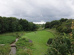
Brierdene
Brierdene or Brier Dene is a small valley[1] through which the Brierdene Burn flows down to its mouth at Whitley Bay.[2] The valley was partly occupied by a coal mine in the past of which very little is now visible.[3] Part of the valley is now the Brierdene Community Green Space and the Brierdene Wildlife Site.[4] The site is now home to more than 1000 identified organisms and includes an ecologically diverse meadow and is a designated Site of Nature Conservation Importance.[2][4] Much of work of transforming the valley into a wildlife refuge was undertaken by a voluntary group - the Friends of Brierdene. This work earned them a Queens Award for Voluntary Service.[5]
The name Brierdene was also used for a railway station built in 1914 but which was never brought into use.
In April 2016 a new housing development at Backworth was started and adopted the name of Brierdene.[6]
References
[edit]- ^ "Brier Dene, North Tyneside". Ordnance Survey. Retrieved 11 June 2023.
- ^ a b "Brierdene". Go-curate- University of Newcastle. Retrieved 11 June 2023.
- ^ "Brierdene - Coal mine". Retrieved 11 June 2023.
- ^ a b "Brierdene Wildlife Site". Retrieved 11 June 2023.
- ^ "Friends of Brierdene". VODA. Retrieved 11 June 2023.
- ^ Sharma, Sonia (27 March 2016). "Work starts on building 180 new homes in Backworth, North Tyneside". ChronicleLive. Retrieved 7 June 2023.


