Donnybrook, KwaZulu-Natal
Appearance
(Redirected from Donnybrook, KwaZulu–Natal)
Donnybrook | |
|---|---|
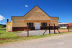
 A building in Donnybrook | |
| Coordinates: 29°45′S 30°0′E / 29.750°S 30.000°E | |
| Country | South Africa |
| Province | KwaZulu-Natal |
| District | Harry Gwala |
| Municipality | Dr Nkosazana Dlamini-Zuma |
| Area | |
• Total | 15.10 km2 (5.83 sq mi) |
| Population (2011)[1] | |
• Total | 4,683 |
| • Density | 310/km2 (800/sq mi) |
| Racial makeup (2011) | |
| • Black African | 98.4% |
| • Coloured | 0.3% |
| • Indian/Asian | 0.3% |
| • White | 0.4% |
| • Other | 0.6% |
| First languages (2011) | |
| • Zulu | 92.8% |
| • S. Ndebele | 1.5% |
| • Tswana | 1.4% |
| • Sotho | 1.1% |
| • Other | 3.2% |
| Time zone | UTC+2 (SAST) |
| PO box | 3237 |
| Area code | 039 |
Donnybrook is a settlement in Harry Gwala District Municipality in the KwaZulu-Natal province of South Africa.
The village is some 80 km southwest of Pietermaritzburg. It was named after Donnybrook, a suburb of Dublin, by Robert Comrie, the owner of the farm on which it was laid out.[2]
Until the mid-1980s, it was the northern terminus of the Umzinto – Donnybrook narrow gauge railway.
References
[edit]- ^ a b c d "Main Place Donnybrook". Census 2011.
- ^ "Dictionary of Southern African Place Names (Public Domain)". Human Science Research Council. p. 141.


