District 10, Ho Chi Minh City
Appearance
(Redirected from District 10 (Ho Chi Minh city))
District 10
Quận 10 | |
|---|---|
Clockwise from top: Workers' Statue at Ngã Bảy Roundabout, Thống Nhất Stadium, and Hòa Bình Theater | |
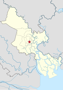
 Position in Ho Chi Minh City's metropolitan area | |
| Coordinates: 10°46′25″N 106°40′2″E / 10.77361°N 106.66722°E | |
| Country | |
| Centrally governed city | Ho Chi Minh City |
| Seat | 474 Ba Tháng Hai |
| Wards | 15 phường |
| Area | |
• Total | 5.7181 km2 (2.2078 sq mi) |
| Elevation | 2 m (7 ft) |
| Population (2018) | |
• Total | 399,000 |
| • Density | 70,000/km2 (180,000/sq mi) |
| Demographics | |
| • Main ethnic groups | predominantly Kinh |
| Time zone | UTC+07 (ICT) |
| Website | quan10.gov.vn |
District 10 (Vietnamese: Quận 10) is an urban district (quận) of Ho Chi Minh City, the largest city in Vietnam.
As of 2017, the district had a population of 239,053 and an area of 5.7181 km2, occupying 0.24% of the city's total land area.[1] It is divided into 15 small subsets which are called wards (phường), numbered from Ward 1 to Ward 15.
Geographical location
[edit]
District 10 borders Tân Bình District to the north, District 5 to the south, District 3 to the east, and District 11 to the west.
References
[edit]Wikimedia Commons has media related to District 10, Ho Chi Minh City.
- ^ "Giới thiệu về Quận 10" [About District 10] (in Vietnamese). 6 December 2017. Retrieved 30 July 2021.


