Devprayag
Devprayag
Devprayag | |
|---|---|
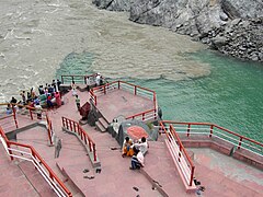
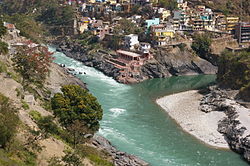
 Confluence of Alaknanda River and the Bhagirathi and the beginning of the main stem of the Ganges river, or Ganga | |
| Coordinates: 30°08′46″N 78°35′53″E / 30.146°N 78.598°E | |
| Country | |
| State | Uttarakhand |
| Population | |
| • Total | 2,144 |
Devprayag (Deva prayāga) is a town and a nagar panchayat, near New Tehri city in Tehri Garhwal District[1][2] in the state of Uttarakhand, India, and is the final one of the Panch Prayag (five confluences) of Alaknanda River where Alaknanda meets the Bhagirathi river and both rivers thereafter flow on as the Ganges river or Ganga.
Overview
[edit]Traditionally, it is considered to be the place where sage Dev Sharma led his ascetic life, giving birth to its present name, Devprayag. It is one of the five sacred confluences in the hills and is an important place of pilgrimage for devout Hindus.[3]
"Devprayag" means "Godly Confluence" in Sanskrit. According to Hindu scriptures, Devprayag is the sacred place of merging of two visible heavenly rivers, Alaknanda and Bhagirathi, to form the holy Ganges.
On a terrace in the upper part of the village is the temple of Raghunathji, built of huge stones, pyramidal in form, and capped by a white cupola.[4] There are major four temples located on this Godly Confluence. These temples increase the spiritual importance of Devprayag.[5]
Geography
[edit]The Alaknanda rises at the confluence and feet of the Satopanth and Bhagirath Kharak glacier in Uttarakhand near the border with Tibet. The headwaters of the Bhagirathi are formed at Gaumukh, at the foot of the Gangotri glacier and Khatling glaciers in the Garhwal Himalaya. These two sacred rivers join to form the Ganges (Ganga) in Devprayag.
Devprayag is 70 km from Rishikesh. Devprayag has an average elevation of 830 metres (2,723 feet).
Demographics
[edit]
As of 2001[update] India census,[6] Devprayag had a population of 2144. Males constitute 52% of the population and females 48%. Devprayag has an average literacy rate of 77%, higher than the national average of 74.5%; male literacy is 82% and, female literacy is 72%. In Devprayag, 13% of the population is under 6 years of age. The town is the seat of the pandas of the Badrinath Dham.
In popular culture
[edit]Devprayag has been featured prominently in the films Kisna: The Warrior Poet and Ponga Pandit.
Transport
[edit]Air
[edit]The nearest airport is the Jolly Grant Airport near Dehradun 116 km (72 mi) away.
Railway
[edit]The nearest railway stations is at Rishikesh. However, Rishikesh is a small railway station not connected by fast trains. Haridwar railway junction, 24 km farther from Rishikesh, has train connections to most of the major cities in India and is, therefore, the railhead for Devprayag.
Road
[edit]Devprayag lies on national highway NH58 that connects Delhi with Badrinath and Mana Pass in Uttarakhand near Indo-Tibet border. Therefore, all the buses and vehicles that carry pilgrims from New Delhi to Badrinath via Haridwar and Rishikesh in pilgrim season of summer months pass through Devprayag on the way to Joshimath and further north. Rishikesh is the major starting point for road journey to Devprayag and regular buses operate from Rishikesh bus station to Devprayag. The road distance from Rishikesh to Devprayag is 74 km (46 mi).
- Haridwar to Rishikesh 24 km
- Rishikesh to Devprayag 74 km
- Devprayag to Srinagar 34 km
- Srinagar to Rudraprayag 33 km
Gallery
[edit]-
Devprayag after the monsoons in October 2019
-
The Bhagirathi (left) joins the Alaknanda (right) at Devprayag
-
The sediment-laden Alaknanda river flowing into Devprayag.
-
Devprayag - where Alaknanda and Bhagirathi rivers meet and take the name Ganga or Ganges River.
-
Devprayag the confluence of Bhagirathi and Alaknanda rivers. The river gets the name "Ganges" (or Ganga) beyond Devprayag
-
Alaknanda and Bhagirathi sangam at Devprayag. Now the river is known as Ganga
-
Devprayag sangam
See also
[edit]- Rudraprayag
- Ganges River (Also known as Ganga in India)
References
[edit]- ^ Fast facts About Devprayag[dead link] Unique Travel Point website.
- ^ Map of Pauri Garhwal district[permanent dead link] Pauri Garhwal District Official website.
- ^ [1] Tehri Garhwal district, Official website.
- ^ One or more of the preceding sentences incorporates text from a publication now in the public domain: Chisholm, Hugh, ed. (1911). "Devaprayag". Encyclopædia Britannica. Vol. 8 (11th ed.). Cambridge University Press. p. 120.
- ^ Sharma, Snehil (10 May 2020). "What is so special about "Devprayag Sangam"?". Humari Baat. pp. 2-3–4-5. Retrieved 10 May 2020.
- ^ "Census of India 2001: Data from the 2001 Census, including cities, villages and towns (Provisional)". Census Commission of India. Archived from the original on 16 June 2004. Retrieved 1 November 2008.


