Dêrong County
Appearance
(Redirected from Derong County)
Dêrong County
得荣县 • སྡེ་རོང་རྫོང་། Derong | |
|---|---|
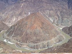
 A bend on the Jinsha River in Dêrong County on the border between Sichuan and Yunan. | |
 Location of the county (red) in Garzê Prefecture (yellow) and Sichuan province | |
| Coordinates: 28°44′N 99°17′E / 28.733°N 99.283°E | |
| Country | China |
| Province | Sichuan |
| Autonomous prefecture | Garzê |
| County seat | Waka |
| Area | |
• Total | 2,916 km2 (1,126 sq mi) |
| Population (2020)[1] | |
• Total | 24,748 |
| • Density | 8.5/km2 (22/sq mi) |
| Time zone | UTC+8 (China Standard) |
| Website | www |
| Dêrong County | |||||||||||
|---|---|---|---|---|---|---|---|---|---|---|---|
| Chinese name | |||||||||||
| Simplified Chinese | 得荣县 | ||||||||||
| Traditional Chinese | 得榮縣 | ||||||||||
| |||||||||||
| Tibetan name | |||||||||||
| Tibetan | སྡེ་རོང་རྫོང་། | ||||||||||
| |||||||||||
Dêrong County (Tibetan: སྡེ་རོང་རྫོང་།; Chinese: 得荣县) is a county in the southwest of Sichuan Province, China, bordering Yunnan province to the east, south, and west. It is under the administration of the Garzê Tibetan Autonomous Prefecture.
Administrative divisions
[edit]Dêrong County is divided into 4 towns and 6 townships.
| Name | Simplified Chinese | Hanyu Pinyin | Tibetan | Wylie | Administrative division code | |
|---|---|---|---|---|---|---|
| Towns | ||||||
| Waka Town | 瓦卡镇 | Wǎkǎ Zhèn | ཝ་ཁ་གྲོང་རྡལ། | wa kha grong rdal | 513338101 | |
| Bünsum Town (Baisong) |
白松镇 | Báisōng Zhèn | སྤུན་གསུམ་གྲོང་རྡལ། | spun gsum grong rdal | 513338102 | |
| Siyü Town (Riyu) |
日雨镇 | Rìyǔ Zhèn | གཟི་ཡུལ་གྲོང་རྡལ། | gzi yul grong rdal | 513338103 | |
| Nyimailungba Town (Taiyanggu) |
太阳谷镇 | Tàiyánggǔ Zhèn | ཉི་མའི་ལུང་པ་གྲོང་རྡལ། | nyi ma'i lung pa grong rdal | 513338104 | |
| Townships | ||||||
| Yulung Township (Xulong) |
徐龙乡 | Xúlóng Xiāng | གཡུ་ལུང་ཤང་། | g.yu lung shang | 513338201 | |
| Bündo Township (Bendu) |
奔都乡 | Bēndū Xiāng | པུ་མདོ་ཤང་། | pu mdo shang | 513338204 | |
| Bündo Township (Bari) |
八日乡 | Bārì Xiāng | ཕག་རི་ཤང་། | phag ri shang | 513338205 | |
| Gêxoi Township (Guxue) |
古学乡 | Gǔxué Xiāng | སྐེད་ཤོད་ཤང་། | sked shod shang | 513338206 | |
| Gongpo Township (Gangbo, Gongbo) |
贡波乡 | Gòngbō Xiāng | སྒོང་ཕོ་ཤང་། | sgong pho shang | 513338208 | |
| Ciu Township (Ciwu) |
茨巫乡 | Cíwū Xiāng | ཚེའུ་ཤང་། | tshe'u shang | 513338210 | |
Climate
[edit]| Climate data for Dêrong, elevation 2,423 m (7,949 ft), (1991–2020 normals, extremes 1981–2010) | |||||||||||||
|---|---|---|---|---|---|---|---|---|---|---|---|---|---|
| Month | Jan | Feb | Mar | Apr | May | Jun | Jul | Aug | Sep | Oct | Nov | Dec | Year |
| Record high °C (°F) | 25.1 (77.2) |
25.9 (78.6) |
29.2 (84.6) |
31.8 (89.2) |
34.2 (93.6) |
36.3 (97.3) |
36.0 (96.8) |
33.6 (92.5) |
33.5 (92.3) |
30.1 (86.2) |
27.1 (80.8) |
22.8 (73.0) |
36.3 (97.3) |
| Mean daily maximum °C (°F) | 15.1 (59.2) |
17.4 (63.3) |
19.9 (67.8) |
23.1 (73.6) |
26.9 (80.4) |
30.1 (86.2) |
28.5 (83.3) |
27.3 (81.1) |
26.9 (80.4) |
24.1 (75.4) |
19.6 (67.3) |
15.8 (60.4) |
22.9 (73.2) |
| Daily mean °C (°F) | 6.1 (43.0) |
8.9 (48.0) |
12.0 (53.6) |
15.5 (59.9) |
19.6 (67.3) |
23.0 (73.4) |
21.7 (71.1) |
20.4 (68.7) |
19.8 (67.6) |
16.1 (61.0) |
10.5 (50.9) |
6.4 (43.5) |
15.0 (59.0) |
| Mean daily minimum °C (°F) | −0.5 (31.1) |
2.0 (35.6) |
5.6 (42.1) |
9.2 (48.6) |
13.5 (56.3) |
17.4 (63.3) |
17.1 (62.8) |
16.0 (60.8) |
14.8 (58.6) |
10.0 (50.0) |
4.0 (39.2) |
−0.1 (31.8) |
9.1 (48.4) |
| Record low °C (°F) | −8.9 (16.0) |
−5.2 (22.6) |
−1.0 (30.2) |
2.1 (35.8) |
3.6 (38.5) |
10.2 (50.4) |
6.6 (43.9) |
11.4 (52.5) |
7.6 (45.7) |
2.1 (35.8) |
−1.9 (28.6) |
−7.7 (18.1) |
−8.9 (16.0) |
| Average precipitation mm (inches) | 1.3 (0.05) |
1.5 (0.06) |
4.4 (0.17) |
6.8 (0.27) |
18.6 (0.73) |
39.1 (1.54) |
126.8 (4.99) |
111.1 (4.37) |
35.3 (1.39) |
9.1 (0.36) |
3.3 (0.13) |
0.4 (0.02) |
357.7 (14.08) |
| Average precipitation days (≥ 0.1 mm) | 1.0 | 1.2 | 2.6 | 4.1 | 5.4 | 9.3 | 18.7 | 17.9 | 9.2 | 3.5 | 1.2 | 0.4 | 74.5 |
| Average snowy days | 1.2 | 0.7 | 0.2 | 0 | 0 | 0 | 0 | 0 | 0 | 0 | 0.1 | 0.2 | 2.4 |
| Average relative humidity (%) | 34 | 33 | 35 | 38 | 40 | 45 | 61 | 67 | 58 | 47 | 40 | 35 | 44 |
| Mean monthly sunshine hours | 174.1 | 163.2 | 178.3 | 169.0 | 174.0 | 154.1 | 121.7 | 118.8 | 125.8 | 163.0 | 170.3 | 175.5 | 1,887.8 |
| Percent possible sunshine | 53 | 51 | 48 | 44 | 41 | 37 | 29 | 29 | 34 | 46 | 53 | 55 | 43 |
| Source: China Meteorological Administration[2][3] | |||||||||||||
References
[edit]- ^ "甘孜州第七次全国人口普查公报(第二号)" (in Chinese). Government of Garzê Prefecture. 2021-06-04.
- ^ 中国气象数据网 – WeatherBk Data (in Simplified Chinese). China Meteorological Administration. Retrieved 14 April 2023.
- ^ 中国气象数据网 (in Simplified Chinese). China Meteorological Administration. Retrieved 14 April 2023.


