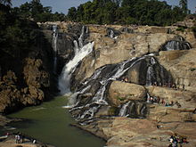
Dassam Falls
| Dassam Falls | |
|---|---|
दशम जलप्रपात | |
 Dassam Water Falls | |
 | |
| Location | Ranchi district, Jharkhand, India |
| Coordinates | 23°08′36″N 85°27′59″E / 23.143358°N 85.466441°E |
| Elevation | 336 metres (1,102 ft) |
| Total height | 44 metres (144 ft) |
| Number of drops | 2 |
| Average width | d |
| Watercourse | Kanchi River |
The Dassam Falls (also known as Dassam Ghagh) is a waterfall located near Taimara village in the Bundu subdivision of Ranchi district in the Indian state of Jharkhand.[1] The Falls are 144 feet in height, formed by the waterflow of the Kanchi River.[2]
Etymology
[edit]Dassam is a changed form of word Da:song which means in mundari language the act of pouring water. Da: means water and song means pouring or measuring. The water fall resembles like somebody is pouring water so the name was Da:song earlier but afterwards the name was changed to Dassam.
Geography
[edit]
10miles
Karanpura Area
River
River
River
River
River
River
River
Dam
Falls
M: municipality, CT: census town, R: rural/ urban centre, N: neighbourhood, T: tourist centre, D: dam, H: historical/ religious centre
Owing to space constraints in the small map, the actual locations in a larger map may vary slightly
Location
[edit]Dassam Falls is located at 23°08′36″N 85°27′59″E / 23.143358°N 85.466441°E.
Note: The map alongside presents some of the notable locations in the district. All places marked in the map are linked in the larger full screen map.
The falls
[edit]
The Dassam Falls is a natural cascade across the Kanchi River, a tributary of the Subarnarekha River. The water falls from a height of 44 metres (144 ft).[3] The sound of water echoes all around the place.[4] Dassam Falls at one of the edges of the Ranchi plateau is one of the many scarp falls in the region.[5]
The Dassam Falls is an example of a nick point caused by rejuvenation. Knick point, also called a nick point or simply nick, represents breaks in slopes in the longitudinal profile of a river caused by rejuvenation. The break in channel gradient allows water to fall vertically giving rise to a waterfall.[6]
The water of the Dassam Falls is very clean and clear. It is natural for a tourist to be enticed to enter the water for a bath or swim but tourists are warned not to do so because of the current that is generated. There have been many cases of drowning in Dassam Falls.[7] Nine people died of drowning between 2001 and 2006. [8]
Transport
[edit]The Dassam Falls is 40 kilometres (25 mi) from Ranchi on NH 33 (now NH-18) or Ranchi-Jamshedpur highway.
External links
[edit] Ranchi travel guide from Wikivoyage
- Jharkhand Tourism Attractions
See also
[edit]References
[edit]- ^ "Dassam Falls". Ranchi district administration. Archived from the original on 24 January 2010. Retrieved 24 April 2010.
- ^ "The water of the Kanchi River falls from a height of about 144 feet forming Dassam Falls".
- ^ "Dassam Falls". must see India. Archived from the original on 24 June 2015. Retrieved 24 April 2010.
- ^ "Dassam Falls". mapsofindia. Archived from the original on 22 June 2011. Retrieved 24 April 2010.
- ^ Bharatdwaj, K. (2006). Physical Geography: Hydrosphere By K. Bharatdwaj. Discovery Publishing House. ISBN 9788183561679. Retrieved 20 April 2010.
- ^ A.Z.Bukhari (2005). Encyclopedia of nature of geography. Anmol Publications Pvt. Limited. ISBN 9788126124435. Retrieved 11 July 2010.
{{cite book}}:|work=ignored (help)[permanent dead link] - ^ "Four drown at Dassam". Calcutta, India: The Telegraph, 21 March 2010. 21 March 2010. Archived from the original on 31 March 2010. Retrieved 24 April 2010.
- ^ "Danger warning at tourist hotspots - Death at Dasham Falls spurs statement". Calcutta, India: The Telegraph, 30 December 2006. 30 December 2006. Archived from the original on 24 October 2012. Retrieved 29 April 2010.
