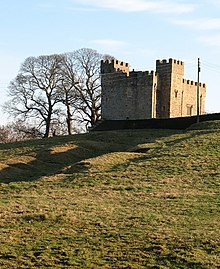
South Cowton Castle

South Cowton Castle is a 15th-century fortified dwelling house in the Richmondshire district of North Yorkshire, England. It is situated on the land that was once the medieval village of South Cowton.[1]
The castle was built by Sir Richard Conyers in 1470 and it is the oldest surviving building in any of the Cowtons.[2] The castle was built at the time of the Wars of the Roses, which gives an indication of why what is a country gentleman's house is so heavily fortified.[3]
The castle is a grade I listed building; it is situated near the 15th century St Mary's Church, and overlooks the field markings from the abandoned village of South Cowton.[4]
The building is rectangular in plan, with two towers at the south western and north eastern corners. It is three storeyed with four-storey towers. The castle was altered in the 19th century and, after a roof-fall in 1979, repaired between 1980 and 1982.[3][5]
The castle is now used as a private farmhouse, it can be found just off the B1263 road near Atley Hill.[6][7]
References
[edit]- ^ Historic England. "South Cowton deserted medieval village, immediately south west of Cowton Castle (1015992)". National Heritage List for England. Retrieved 20 August 2018.
- ^ Pettifer, Adrian (1995). English Castles; a Guide by Counties. Woodbridge: Boydell Press. p. 289. ISBN 0-85115-600-2.
- ^ a b "Beautiful south". The Northern Echo. 23 January 2013. Retrieved 20 August 2018.
- ^ Historic England. "Cowton Castle (Grade I) (1294712)". National Heritage List for England. Retrieved 20 August 2018.
- ^ Emery, Anthony (1996). Greater Medieval Houses of England and Wales 1300–1500. Cambridge: Cambridge University Press. p. 398. ISBN 052149723X.
- ^ Historic England. "Cowton Castle (23573)". Research records (formerly PastScape). Retrieved 20 August 2018.
- ^ "304" (Map). Darlington & Richmond. 1:25,000. Explorer. Ordnance Survey. 2015. ISBN 9780319245569.
