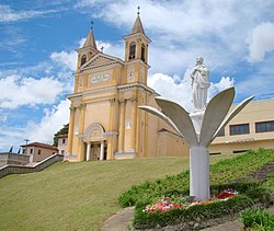
Colombo, Paraná
Appearance
Colombo | |
|---|---|
 Church Hall, whose construction began in 1898. | |
|
| |
 Location of Colombo | |
| Coordinates: 23°47' S 46°58' W | |
| Country | Brazil |
| State | Paraná |
| Government | |
| • Mayor | Beti Pavin |
| Area | |
• Total | 198.7 km2 (76.7 sq mi) |
| Elevation | 950 m (3,120 ft) |
| Population (2020 [1]) | |
• Total | 246,540 |
| • Density | 1,200/km2 (3,200/sq mi) |
| Time zone | UTC−3 (BRT) |
Colombo is a city of about 247,000 inhabitants in the Southern Brazilian state of Paraná; is the third largest city in Greater Curitiba, with the largest one being Curitiba.[2]
It was founded on 5 February 1890. It is located at 25º17'30" S, 49º13'27" W, at an elevation of about 1000 metres above sea level, some 18 km from state capital Curitiba. The city is the largest Italian colony in the state.[3]
Climate
[edit]| Climate data for Colombo (1991-2021) | |||||||||||||
|---|---|---|---|---|---|---|---|---|---|---|---|---|---|
| Month | Jan | Feb | Mar | Apr | May | Jun | Jul | Aug | Sep | Oct | Nov | Dec | Year |
| Mean daily maximum °C (°F) | 24.6 (76.3) |
24.8 (76.6) |
23.9 (75.0) |
22.3 (72.1) |
19 (66) |
18.3 (64.9) |
18.1 (64.6) |
19.7 (67.5) |
20.9 (69.6) |
22.2 (72.0) |
22.6 (72.7) |
24.2 (75.6) |
21.7 (71.1) |
| Daily mean °C (°F) | 20.5 (68.9) |
20.6 (69.1) |
19.9 (67.8) |
18.2 (64.8) |
15.1 (59.2) |
14 (57) |
13.5 (56.3) |
14.6 (58.3) |
15.9 (60.6) |
17.5 (63.5) |
18.2 (64.8) |
19.8 (67.6) |
17.3 (63.2) |
| Mean daily minimum °C (°F) | 17.7 (63.9) |
17.9 (64.2) |
17.2 (63.0) |
15.3 (59.5) |
12.1 (53.8) |
10.8 (51.4) |
10.1 (50.2) |
10.7 (51.3) |
12.4 (54.3) |
14.1 (57.4) |
15.7 (60.3) |
16.7 (62.1) |
14.2 (57.6) |
| Average precipitation mm (inches) | 245 (9.6) |
197 (7.8) |
135 (5.3) |
79 (3.1) |
93 (3.7) |
95 (3.7) |
95 (3.7) |
74 (2.9) |
132 (5.2) |
130 (5.1) |
131 (5.2) |
168 (6.6) |
1,574 (61.9) |
| Average rainy days | 17 | 15 | 14 | 8 | 7 | 6 | 6 | 5 | 8 | 11 | 11 | 11 | 119 |
| Average relative humidity (%) | 86 | 86 | 85 | 83 | 83 | 84 | 82 | 80 | 81 | 83 | 83 | 84 | 83 |
| Mean monthly sunshine hours | 189.1 | 180.8 | 176.7 | 165 | 158.1 | 174 | 189.1 | 210.8 | 180 | 170.5 | 168 | 195.3 | 2,157.4 |
| Mean daily sunshine hours | 6.1 | 6.4 | 5.7 | 5.5 | 5.1 | 5.8 | 6.1 | 6.8 | 6.0 | 5.5 | 5.6 | 6.3 | 5.9 |
| Source: Climate data (sun 1999-2019)[4] | |||||||||||||
References
[edit]- ^ "IBGE Columbo 2020".
- ^ "Curitiba", Wikipedia, 2023-03-06, retrieved 2023-03-06
- ^ "Colombo prepara 15ª Festa do Vinho" (in Portuguese). Jornal Agora Paraná. Retrieved 2009-05-11.[permanent dead link]
- ^ "Clima Colombo (Brasil)" [Colombo Climate (Brazil)]. Climate data (in Portuguese). Retrieved 28 July 2024.


