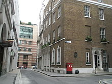
St Mary Colechurch
| St Mary Colechurch | |
|---|---|
 Current picture of site | |
 | |
| Location | London |
| Country | United Kingdom |
| Denomination | Church of England |
| Architecture | |
| Years built | 10th century |
| Demolished | 1666 |
| Administration | |
| Diocese | London |
St Mary Colechurch was a parish church in the City of London destroyed in the Great Fire of London in 1666 and not rebuilt.[1]
History
[edit]The church was situated at the junction of Poultry and the south end of Old Jewry.[2] Named after its first benefactor,[3] it was a prosperous parish[4] able to support a grammar school,[5] which was rebuilt on the site after the fire and continued in that locality until 1787.
The Great Fire of London of 1666 destroyed 86 of the 97 parish churches in the City of London.[6] By 1670 a Rebuilding Act had been passed and a committee set up under of Sir Christopher Wren to plan the new parishes.[7] Fifty-one were chosen, but St Mary Colechurch was one of the minority not to be rebuilt.[8] The parish was united with St Mildred, Poultry, although the parishioners objected on the grounds that
This was a noisy, crowded parish perpetually disturbed by carts and coaches, and wants sufficient place for burials.[9]
When St Mildred's too was deemed surplus to requirements,[10] following the passing of the 1860 Union of Benefices Act, it passed successively through partnerships with St Olave Jewry and St Margaret Lothbury.[11] C. W. Pearce[12] notes that the last traces of any building vanished in 1839 although a Parish Boundary Mark inside the Mercers’ Hall still exists.[13]


A plaque commemorates the church on the southwest corner of Old Jewry. The site is currently occupied by the Alliance & Leicester at 82 Cheapside.
References
[edit]- ^ Hibbert, C.; Weinreb, D.; Keay,J. (2008) [1983]. The London Encyclopaedia. London: Pan Macmillan. ISBN 978-1405049245.
- ^ Borer, M. I. C. (1978). The City of London: a history. New York: D. McKay. ISBN 0094618801.
- ^ A Survey of London; by Stow, J. A. (W. Thoms, ed.) London: A. Whittaker & Co, 1842 (revision of 1598 book)
- ^ Historical Gazetteer of London before the Great Fire; 1, Cheapside: Parishes of All Hallows Honey Lane, St. Martin Pomary, St. Mary le Bow, St. Mary Colechurch, and St. Pancras Soper Lane; Keene, D & Harding, V. Cambridge: Chadwyck-Healey, 1987 ISBN 0859641902
- ^ Huelin, G. (1996). Vanished Churches of the City of London. London: Guildhall Library Publications. ISBN 0900422424.
- ^ The Churches of the City of London; Reynolds, H. London: Bodley Head, 1922
- ^ Wren; Whinney, M. London: Thames & Hudson, 1971 ISBN 0500201129
- ^ The City of London Churches; Betjeman, J. Andover: Pitkin, 1967 (reprint 1992) ISBN 0853725659
- ^ "Representations to Wren's Committee, 1670" in The London City Churches; Norman, P. London: the London Society, 1929
- ^ The History of the Church of St. Mildred the Virgin, Poultry, in the City of London, with some particulars of the church of St. Mary Colechurch; Milbourn, T. London: John Russell Smith, 1872
- ^ "Church of England, Parish of St. Margaret Lothbury. – Papers relating to the proposed union of the rectory of St Margaret Lothbury, 1883.” – M0023569CL cited in City of London Parish Registers Guide 4; Hallows, A.(ed.) London: Guildhall Library Research, 1974 ISBN 0900422300
- ^ Notes on Old City Churches: their organs, organists and musical associations; Pearce, C. W. London: Winthrop Rogers Ltd 1909
- ^ Premier Livery Company
