Cobridge
| Cobridge | |
|---|---|
 | |
Location within Staffordshire | |
| OS grid reference | SJ875490 |
| District | |
| Shire county | |
| Region | |
| Country | England |
| Sovereign state | United Kingdom |
| Post town | STOKE-ON-TRENT |
| Postcode district | ST1 |
| Dialling code | 01782 |
| Police | Staffordshire |
| Fire | Staffordshire |
| Ambulance | West Midlands |
Cobridge is an area of Stoke-on-Trent, in the City of Stoke-on-Trent district, in the county of Staffordshire, England. Cobridge was marked on the 1775 Yates map as 'Cow Bridge'[1] and was recorded in Ward records (1843) as Cobridge Gate.[2]
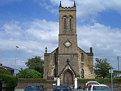
Cobridge has a community centre[3] and a C of E church called Christ Church on Emery Street[4][5] which is Grade II listed.[6]
Cobridge once had a railway station on the Potteries Loop Line.[7]
There was once an old school house in Cobridge, at the bottom of Sneyd Street and demolished in 1897. A Victorian school once stood adjacent to Christ Church on the corner of Emery and Mawdesley Streets. The old Granville school was replaced by the new Forest Park school. St. Peter's Catholic school still exists in the area.[8]
Cobridge was the location of the Athletic Ground, now the site of a sheltered housing and nursing home complex. Circa 1870, it had a population of 3,378 as recorded in the Imperial Gazetteer of England and Wales.[9]
The Headquarters of the Air Training Corps 388 (City of Stoke-on-Trent) Squadron are at the RFCA Centre, Martin Leake House, Waterloo Road.
References
[edit]- ^ Yates, William (1775). A map of the county of Stafford.
- ^ "Cobridge - Stoke-on-Trent Districts". Thepotteries.org. 28 January 2008. Retrieved 8 July 2011.
- ^ "Map - Directions | Cobridge Community Centre | Community Centres, Stoke-On-Trent". Yell.com. Archived from the original on 27 September 2011. Retrieved 8 July 2011.
- ^ A Church Near You. "Christ Church, Cobridge - Staffordshire | Diocese of Lichfield". Achurchnearyou.com. Retrieved 8 July 2011.
- ^ "Christ Church, Cobridge:: OS grid SJ8748 :: Geograph Britain and Ireland - photograph every grid square!". Geograph.org.uk. 27 July 2006. Retrieved 8 July 2011.
- ^ Good Stuff IT Services (15 March 1993). "Christ Church - Stoke On Trent - Staffordshire - England". British Listed Buildings. Retrieved 8 July 2011.
- ^ "Latest News and Information on Cobridge Railway Station". Eastgrinsteadliving.info. Archived from the original on 26 March 2012. Retrieved 8 July 2011.
- ^ "Cobridge - Stoke-on-Trent Districts". Thepotteries.org. Retrieved 8 July 2011.
- ^ "History of Cobridge, in Stoke on Trent and Staffordshire". Vision of Britain. Retrieved 25 November 2018.
External links
[edit]- Cobridge Station at thepotteries.org
- Images for SJ8748 at Geograph Britain and Ireland
- Cobridge - 'the changing face of Cobridge' at thepotteries.org
- Cobridge streets at thepotteries.org
- Cobridge, Staffordshire at the FamilySearch Research Wiki
- Christ Church, Cobridge at Hanley Team Ministry

