Ciénega de Flores
Appearance
(Redirected from Cienega de Flores)
This article needs additional citations for verification. (September 2014) |
Ciénega de Flores | |
|---|---|
Municipality | |
 | |
| Coordinates: 25°57′N 100°11′W / 25.950°N 100.183°W | |
| Country | Mexico |
| State | Nuevo León |
| Settled | 1675 |
| Government | |
| • Presidente Municipal | Pedro Alonso Casas Quiñones |
| Area | |
• Total | 138.7 km2 (53.6 sq mi) |
| Population (2005 INEGI Census) | |
• Total | 14,268 |
| • Density | 100/km2 (270/sq mi) |
| Time zone | UTC-6 (CST) |
| • Summer (DST) | UTC-5 (CDT) |
| Codigo Postal | |
| Area code | +52-825 |
| Website | Municipio de Ciénega de Flores |
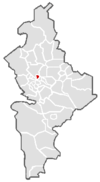
Ciénega de Flores is a city and surrounding municipality located in Nuevo Leon, Mexico near Monterrey. It has a large Bridgestone tire factory opened in 2007.
Tradition
[edit]Ciénega de Flores is recognized by its famous machacado (dry meat) food, which is one of the traditional foods in Nuevo León.[1]
Demographics
[edit]According to the INEGI 2005 census Ciénega de Flores had a population of 14,268, which 5,735 are male and 5,469 are female. Out of the total population 37 or 0.39% were Native Indian. 8,117 of the total population were Catholic and 1,318 were affiliated to other religions. There are 3,497 household of which 3,370 are owner occupied.

References
[edit]Wikimedia Commons has media related to Ciénega de Flores.
- ^ Chavez, Stephen; Rodriguez, Art (26 December 2013). "Latino Recipes for the Holidays: Machaca Con Huevos". HuffPost.

