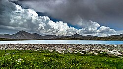
Diamer District
Diamir District
ضلع دیامر | |
|---|---|
 Shanrgah Lake in Shatti Choi Valley | |
 | |
| Country | |
| Territory | |
| Division | Diamer Division |
| Headquarters | Chilas |
| Government | |
| • Type | District Administration |
| • Deputy Commissioner | N/A |
| • District Police Officer | N/A |
| • District Health Officer | N/A |
| Area | |
• Total | 10,936 km2 (4,222 sq mi) |
| Population (2013) | |
• Total | 214,000 |
| Number of tehsils | 2 |
Diamer District (Urdu: ضلع دیامر), also spelled Diamir District,[1][2]) is a district in the Gilgit-Baltistan region administered by Pakistan. The headquarters of the district is the town of Chilas. The district is bounded on the north by the Tangir and the Gilgit districts, on the east by the Astore District, on the south by the Mansehra district of Pakistan's Khyber Pakhtunkhwa Province and the Neelum District of Pakistan controlled Kashmir, and on the west by the Upper Kohistan District of Khyber Pakhtunkhwa Province. The Karakoram Highway passes through Diamer District.
History
[edit]Ancient India
[edit]Thalpan, located opposite to the Chilas town, bears the most abundant collection of rock-art in Pakistan — the Pakistan-German Archaeological Mission has published about them in six dedicated volumes and traced them to Greco-Buddhist antiquity.[3][a] Buddhist Stupas and anthropomorphic Buddhas remain the most common subject of rock-carvings in and around Chilas.[4]
Karl Jettmar suggests that Chilas might have had been a Buddhist sanctuary while Harald Hauptmann hypothesizes Thalpan to be the "Talilo" of Chinese sources; however, in absence of excavations, such claims remain in the realm of speculations.[4]
British India
[edit]During the British Raj, the area was known as Chilas and regarded as a tribal area, a subsidiary of the princely state of Jammu and Kashmir.[5][6] Its original name was apparently Shiltās.[7]
The region was brought under the control of the Maharaja of Jammu and Kashmir in 1851, and an agent of the Kashmir durbar was stationed there.[8] In 1893, Chilas was taken over by the British-run Gilgit Agency.[9] An Assistant Political Agent of the Agency was stationed in Chilas town.[10][11] The Raja was soon deposed and Chilas functioned as a 'republican community' under the aegis of jirga, a body of local landowning men.[12][13]
Pakistan
[edit]Prior to 2019, the Darel District and the Tangir District were part of the Diamer District. They were subsequently elevated to district status.[14] The jirga continues to play a significant role in governance.[13]
Demographics
[edit]Diamer is the only Sunni-majority district in Gilgit-Baltistan.
Transportation
[edit]Before the Karakoram Highway was opened in 1978, the only road from the south to the town of Gilgit was a rough track north from Balakot to the Babusar Pass (via Kaghan, Naran, Besal, and Gittidas) and further north from Babusar Gah to Chilas. The road up to Besal is better than it was previously, and the road from Besal to the Babusar Pass is good, having been recently metaled.
See also
[edit]Notes
[edit]- ^ The proposed construction of Basha-Diamer Dam is expected to inundate over 37,000 carvings.
References
[edit]- ^ Guide to Standard Floras of the World: An Annotated, Geographically Arranged Systematic Bibliography of the Principal Floras, Enumerations, Checklists and Chorological Atlases of Different Areas 2, revised: David G. Frodin Published by Cambridge University Press, 2001, Page R79
- ^ Islam, Women, and Violence in Kashmir: Between India and Pakistan: Nyla Ali Khan Published by Palgrave Macmillan, 2010, Page 9
- ^ Zahir, Muhammad. "Discovery and Contextualization of a Possible Buddhist Monastic Complex at Thalpan, District Diamer, Gilgit-Baltistan Province, Pakistan". Gandhāran Studies. 13: 37–59.
- ^ a b van Aerde, Marike (2019), Yang, Liang Emlyn; Bork, Hans-Rudolf; Fang, Xiuqi; Mischke, Steffen (eds.), "Routes Beyond Gandhara: Buddhist Rock Carvings in the Context of the Early Silk Roads", Socio-Environmental Dynamics along the Historical Silk Road, Cham: Springer International Publishing, pp. 455–480, doi:10.1007/978-3-030-00728-7_20, hdl:1887/83304, ISBN 978-3-030-00728-7, retrieved 2022-05-16
- ^ Snedden, Christopher (2015), Understanding Kashmir and Kashmiris, Oxford University Press, pp. 117–118, ISBN 978-1-84904-342-7
- ^ Gazetteer of Kashmir and Ladak, Calcutta: Superintendent of Government Printing, 1890, p. 11 – via archive.org
- ^ Stein, M. A. (1989) [first published 1900], Kalhana's Rajatarangini: A chronicle of the kings of Kashmir, Volume 2., Motilal Banarsidass Publ., p. 363, ISBN 978-81-208-0370-1
- ^ Chohan 1997, p. 118.
- ^ Chohan 1997, pp. 127, 189.
- ^ Chohan 1997, p. 215.
- ^ Brown, William (2014), Gilgit Rebelion: The Major Who Mutinied Over Partition of India, Pen and Sword, p. 53, ISBN 9781473821873
- ^ Bangash, Yaqoob Khan (2010), "Three Forgotten Accessions: Gilgit, Hunza and Nagar", The Journal of Imperial and Commonwealth History, 38 (1): 122, doi:10.1080/03086530903538269, S2CID 159652497
- ^ a b Sökefeld, Martin (2014). "Anthropology of Gilgit-Baltistan: Introduction". Ethnoscripts (in German). 16 (1): 11, 17. ISSN 2199-7942.
- ^ "GB cabinet decides to upgrade Dareal, Tangir,Gupis Yasin and Roundu as districts". Radio Pakistan. 20 April 2019. Archived from the original on 19 June 2019. Retrieved 19 June 2019.
Bibliography
[edit]- Chohan, Amar Singh (1997), Gilgit Agency 1877-1935 (Second Reprint ed.), Atlantic Publishers & Dist, ISBN 978-81-7156-146-9 – via archive.org

