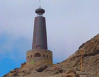
Chañaral
This article contains wording that promotes the subject in a subjective manner without imparting real information. (March 2014) |
Chañaral | |
|---|---|
 Plaza Chañaral | |
| Coordinates: 26°20′40″S 70°37′19″W / 26.34444°S 70.62194°W | |
| Country | |
| Region | |
| Province | Chañaral Province |
| Government | |
| • Type | Municipality |
| • Alcalde | Margarita Flores (PR) |
| Area | |
• Total | 5,772.4 km2 (2,228.7 sq mi) |
| Elevation | 198 m (650 ft) |
| Population (2002 Census)[2] | |
• Total | 13,143 |
| • Density | 2.3/km2 (5.9/sq mi) |
| • Urban | 13,180 |
| • Rural | 363 |
| Sex | |
| • Men | 6,968 |
| • Women | 6,575 |
| Time zone | UTC−4 (CLT) |
| • Summer (DST) | UTC−3 (CLST) |
| Area code | 56 + 52 |
| Climate | BWh |
| Website | www |
Chañaral is a small coastal city and commune in the Atacama Region, Chile and capital of the Chañaral Province. Despite it being coastal, it is not a seaside resort, partly because the ocean is contaminated by the copper mining activity in the area.[3][4][5] Just north of the city lies Pan de Azúcar National Park, a notable natural landmark.
History
[edit]In 1824, Diego de Almeyda discovered significant copper deposits near Chañaral, and hence beginning copper mining and export in the area. For this reason, the town was founded in October 26, 1833 as Chañaral de las Ánimas ("Chañar field of the Souls"). A few years later, Pedro Lujan discovered ore at El Salado where a mine was built. A shipping port was developed in 1836 to support the transport of raw materials, and the town experienced a period of growth starting around 1860 when the mining company A. Edwards & Company established operations there.
Demographics
[edit]According to the 2002 census by the National Statistics Institute (INE) the commune of Chañaral spans an area of 5,772.4 km2 (2,229 sq mi) and had 13,543 inhabitants (6,968 men and 6,575 women). Of these, 13,180 (97.3%) lived in urban areas and 363 (2.7%) in rural areas. The population fell by 2.8% (393 persons) between the 1992 and 2002 censuses.[2]
The demonym for a person from Chañaral is Chañaralino for a man and Chañaralina for a woman.
Administration
[edit]As a commune, Chañaral is a third-level administrative division of Chile administered by a municipal council, headed by an alcalde who is directly elected every four years. Since June 2021 the alcalde is Margarita Flores Salazar (PR), and the council has the following members:[1]
- Diego Vargas P.
- Sebastián González G.
- Quintina Galleguillos G.
- Ema Arnello T.
- Joice Tabilo P.
- John Silva M.
Within the electoral divisions of Chile, Chañaral is represented in the Chamber of Deputies by Daniella Circardini Milla (PS), Sofía Cid|Sofia Cid Versalovic (RN), Jaime Mulet Martinez (FREVS), Juan Santana Castillo (PS) and Cristián Tapia Ramos as part of the 4th electoral district, (together with Diego de Almagro, Copiapó, Caldera, Tierra Amarilla, Freirina, Huasco, Vallenar and Alto del Carmen).[6] The commune is represented in the Senate by Rafael Prohens Espinosa (RN) and Yasna Provoste Campillay (PDC) as part of the 4th senatorial constituency (Atacama).

Climate
[edit]| Climate data for Chañaral | |||||||||||||
|---|---|---|---|---|---|---|---|---|---|---|---|---|---|
| Month | Jan | Feb | Mar | Apr | May | Jun | Jul | Aug | Sep | Oct | Nov | Dec | Year |
| Mean daily maximum °C (°F) | 22.9 (73.2) |
23.2 (73.8) |
22.5 (72.5) |
20.3 (68.5) |
18.4 (65.1) |
16.3 (61.3) |
16.3 (61.3) |
16.4 (61.5) |
16.7 (62.1) |
18.1 (64.6) |
19.5 (67.1) |
21.3 (70.3) |
19.3 (66.8) |
| Mean daily minimum °C (°F) | 15.6 (60.1) |
16.2 (61.2) |
14.8 (58.6) |
12.9 (55.2) |
9.7 (49.5) |
8.8 (47.8) |
8.8 (47.8) |
9.4 (48.9) |
10.2 (50.4) |
11.4 (52.5) |
13.1 (55.6) |
15.1 (59.2) |
12.2 (53.9) |
| Average precipitation mm (inches) | 0.0 (0.0) |
0.0 (0.0) |
0.0 (0.0) |
0.0 (0.0) |
0.0 (0.0) |
0.0 (0.0) |
1.1 (0.04) |
0.0 (0.0) |
0.0 (0.0) |
0.6 (0.02) |
0.0 (0.0) |
0.0 (0.0) |
1.7 (0.06) |
| Average relative humidity (%) | 64 | 64 | 68 | 71 | 75 | 75 | 75 | 76 | 72 | 70 | 67 | 66 | 70 |
| Source: Bioclimatografia de Chile[7] | |||||||||||||
References
[edit]- ^ a b "Municipality of Chañaral" (in Spanish). Retrieved 2 September 2010.
- ^ a b c d "National Statistics Institute" (in Spanish). Archived from the original on 11 January 2012. Retrieved 8 September 2010.
- ^ J.C. Castilla (1983). "Environmental impact in sandy beaches of copper mine tailings at Chañaral, Chile". Marine Pollution Bulletin. 14 (12). Elsevier Ltd.: 459–464. doi:10.1016/0025-326X(83)90046-2.
- ^ J.A. Vasquez, B. Matsuhiro, M.A. Vega, L.M. Pardo, D. Veliz; Matsuhiro; Vega; Pardo; Veliz (2000). "The effects of mining pollution on subtidal habitats of northern Chile". International Journal of Environment and Pollution. 13 (1–6): 2–25. doi:10.1504/IJEP.2000.002330.
{{cite journal}}: CS1 maint: multiple names: authors list (link)[permanent dead link] - ^ J.L. Stauber; S. Andrade; M. Ramirez; M. Adams; J.A. Correa (2005). "Copper bioavailability in a coastal environment of Northern Chile: Comparison of bioassay and analytical speciation approaches". Marine Pollution Bulletin. 50 (11). Elsevier Ltd.: 1363–1372. doi:10.1016/j.marpolbul.2005.05.008. PMID 15993430.
- ^ "Honorable Cámara de Diputadas y Diputados - Chile". www.camara.cl (in Spanish). Retrieved 2023-08-07.
- ^ Hajek, Ernst; Castri, Francesco (1975). "Bioclimatografia de Chile" (PDF) (in Spanish). Archived from the original (PDF) on 22 November 2009. Retrieved 27 May 2024.
External links
[edit]- (in Spanish) Municipality of Chañaral


