Portuguese Ceylon
Portuguese Ceylon Ceilão Português (Portuguese) පෘතුගීසි ලංකාව (Sinhala) pṛtugīsi laṁkāva போர்த்துக்கேய இலங்கை (Tamil) Pōrttukkēya ilaṅkai | |||||||||||||
|---|---|---|---|---|---|---|---|---|---|---|---|---|---|
| 1597[1]–1658 | |||||||||||||
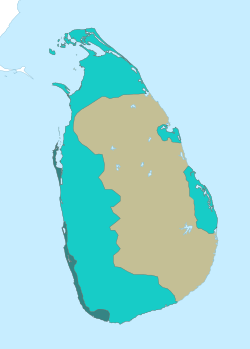
 After the death of King Dharmapala (1597) Portuguese Ceylon at its greatest extent 1594–1619 | |||||||||||||
| Status | Colony of Portugal | ||||||||||||
| Capital | Colombo | ||||||||||||
| Common languages | Portuguese (official) Sinhala Tamil | ||||||||||||
| Religion | Roman Catholicism | ||||||||||||
| King of Portugal | |||||||||||||
• 1597–1598 | Philip I | ||||||||||||
• 1598–1621 | Philip II | ||||||||||||
• 1621–1640 | Philip III | ||||||||||||
• 1640–1656 | John IV | ||||||||||||
• 1656–1658 | Afonso VI | ||||||||||||
| Captain-General | |||||||||||||
• 1597–1614 | Jerónimo de Azevedo | ||||||||||||
• 1656–1658 | António de Amaral de Meneses | ||||||||||||
| Historical era | Colonialism | ||||||||||||
• Portuguese arrival | 1505 | ||||||||||||
• Death of Dharmapala of Kotte | 27 May 1597[1] | ||||||||||||
• Luso–Kandyan Treaty | 1633 | ||||||||||||
• Surrender of Jaffna | June 1658 | ||||||||||||
| |||||||||||||
Portuguese Ceylon (Portuguese: Ceilão Português; Sinhala: පෘතුගීසි ලංකාව; Tamil: போர்த்துக்கேய இலங்கை) is the name given to the territory on Ceylon, modern-day Sri Lanka, controlled by the Portuguese Empire between 1597 and 1658.
Portuguese presence in the island lasted from 1505 to 1658. Their arrival was largely accidental, and the Portuguese sought control of commerce, rather than territory. The Portuguese were later drawn into the internal politics of the island with the political upheaval of the Wijayaba Kollaya, and used these internal divisions to their advantage during the Sinhalese–Portuguese War, first in an attempt to control the production of valuable cinnamon and later of the entire island. Direct Portuguese rule did not begin until after the death of Dharmapala of Kotte, who died without an heir, and had bequeathed the Kingdom of Kotte to the Portuguese monarch in 1580.[2] That allowed the Portuguese sufficient claim to the Kingdom of Kotte upon Dharmapala's death in 1597. Portuguese rule began with much resistance by the local population.[3]
Eventually, the Kingdom of Kandy sought help from the Dutch East India Company, with whom they initially entered into agreement. After the collapse of the Iberian economy in 1627, the Dutch–Portuguese War saw the Dutch conquest of most of Portugal's Asian colonies – Ceylon included, between 1638 and 1658. Nevertheless, elements of Portuguese culture from this colonial period remain in Sri Lanka.
| History of Kandy |
|---|
 |
| Kingdom of Kandy (1469–1815) |
| Colonial Kandy (1815–1948) |
| Kandy (1948–present) |
| See also |
|
|
History
[edit]Arrival and establishment of the Portuguese (1505–1543)
[edit]This section needs expansion. You can help by adding to it. (May 2022) |
Portuguese knew Sri Lanka by the name ''Seylan''. In 1505 King of Portugal instructed General Dom Francisco de Almeida to find the island of ''Seylan'' when he was appointed as the emperor of the East by the Portuguese. When the Portuguese were trying to establish relations with Ceylon, Dom Lourenço de Almeida, son of Dom Francisco de Almeida, and others arrived by chance in 1505 AD. So, the first contact between Sri Lanka and the Portuguese was established by Dom Lourenço de Almeida in 1505. It was largely accidental and it wasn't until 12 years later that the Portuguese sought to establish a fortified trading settlement.[4]
The Kingdom of Kotte as a Portuguese entrance (1543–1597)
[edit]This section is empty. You can help by adding to it. (October 2019) |
Annexation of Kotte and war with Kandy (1597)
[edit]This section needs expansion. You can help by adding to it. (October 2019) |
Direct Portuguese rule began after the death of Dharmapala of Kotte who bequeathed the Kingdom of Kotte to the Portuguese monarch.[5] By 1600 the Portuguese had consolidated the main centers of rebellion, the Kelani and Kalu ganga basins, leaving the border regions to Sinhalese resistance.[6]
Conquest of Jaffna (1619)
[edit]This section is empty. You can help by adding to it. (October 2019) |
Dutch conquest (1638–1658)
[edit]This section is empty. You can help by adding to it. (October 2019) |
Political cities and their kings in Sri Lanka at the time of arrival of the Portuguese
[edit]This section is empty. You can help by adding to it. (January 2023) |
Administration
[edit]Administrative structure
[edit]This section needs expansion. You can help by adding to it. (October 2019) |
Administrative divisions
[edit]This section is empty. You can help by adding to it. (October 2019) |
Taxation
[edit]This section is empty. You can help by adding to it. (October 2019) |
Military
[edit]This section is empty. You can help by adding to it. (October 2019) |
Demographics and ethnicities
[edit]This section is empty. You can help by adding to it. (October 2019) |
Economy
[edit]Cinnamon and black pepper were main spices exported by Portuguese.
Legacy
[edit]This section is empty. You can help by adding to it. (October 2019) |
Food
[edit]There are many foods of Portuguese influence that are still popular in Sri Lanka. For example, lingus and pastries.
Language
[edit]Sinhala words for certain types of Western attire/ furniture/ food & drink are derived from the Portuguese. Some examples are below:
| Sinhala Word | Meaning | Portuguese Word |
|---|---|---|
| Mesaya | Table | Mesa (Table) |
| Almaariya | Cupboard | Armário (Cupboard) |
| Kurusaya | Cross | Cruz (Cross) |
| Toppiya | Hat | Topo (Hat) |
| Kamisaya | Shirt | Camiseta (Shirt) |
| Kalisama | Trousers | Calção (Trousers) |
| Sapaththuwa | Shoe | Sapato (Shoe) |
| Sidaadiya | City | Cidade (City) |
| Bébadda (colloq.) | Drunkard | Bêbado (drunkard) |
| Iskole | School | Escola (School) |
Click here for more examples.....
See also
[edit]References
[edit]- De Silva, K. M. (1981). A History of Sri Lanka. India: University of California Press. ISBN 0-520-04320-0.
- C. Gaston Pereira, Kandy fights the Portuguese. Sri Lanka: Vijitha Yapa Publications, July 2007. ISBN 978-955-1266-77-6
- Channa Wicremasekera, Kandy at War. Sri Lanka: Vijitha Yapa Publications, 2004. ISBN 955-8095-52-4
- Michael Roberts, Sinhala Consciousness in the Kandyan Period. Sri Lanka: Vijitha Yapa Publications, 2004. ISBN 955-8095-31-1,
- Abeysinghe, Tikiri (2005). Jaffna under the Portuguese. Colombo: Stamford Lake. p. 66. ISBN 955-1131-70-1.
- Kunarasa, K (2003). The Jaffna Dynasty. Johor Bahru: Dynasty of Jaffna King’s Historical Society. p. 122. ISBN 955-8455-00-8.
- Gnanaprakasar, Swamy (2003). A Critical History of Jaffna (review of Yalpana Vaipava Malai). New Delhi: Asian Educational Services. p. 122. ISBN 81-206-1686-3.
- Senaka Weeraratna, Repression of Buddhism in Sri Lanka by the Portuguese (1505 - 1658)
External links
[edit]- Ceylon and the Portuguese, 1505–1658, y Paulus Edward Pieris (American Ceylon Mission Press, 1920)
- Portuguese History in Ceylon
- Portuguese Ceylon
- Kingdom of Kotte
- Former Portuguese colonies
- Former countries in South Asia
- States and territories established in 1597
- States and territories disestablished in 1658
- 1597 establishments in Asia
- 1658 disestablishments in Asia
- 16th-century establishments in Sri Lanka
- 17th-century disestablishments in Sri Lanka
- 1597 establishments in the Portuguese Empire
- 1658 disestablishments in the Portuguese Empire
- Transitional period of Sri Lanka


